
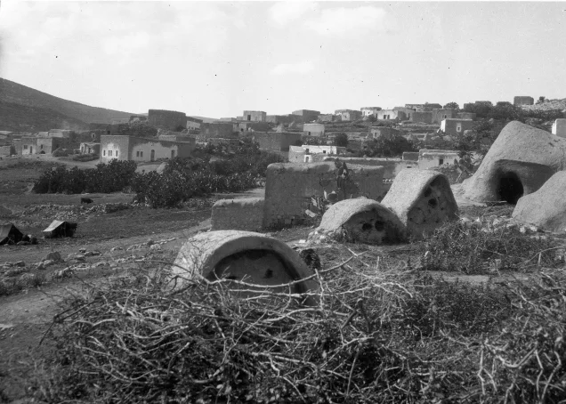
The depopulated village of Al-Shajara / District of Tiberias
Subdistrict: Tiberias
Estimated population of al-Shajara in 1948: Approximately 890
Date of occupation and depopulation: 6 May 1948
Military unit: Golani Brigade, principally the Twelfth Battalion—also known as the Barak Battalion
Israeli settlements established on the village’s registered land before 1948: None
Israeli settlements established on the village’s registered land after 1948: None
Nearby Israeli settlements: Ilaniyya, established as Sejera in 1902, and Sde Ilan, established in 1949
Al-Shajara was a Palestinian village in the Tiberias Subdistrict. Its registered land area amounted to 3,754 dunams, and its population was estimated at approximately 890 on the eve of the Nakba. The Golani Brigade occupied the village on 6 May 1948, after which its inhabitants were displaced and most of its buildings were destroyed during Israel’s occupation of Palestine—the Nakba.
Location of al-Shajara
- Al-Shajara was located approximately 14 kilometres west of Tiberias.
- The village stood at an average elevation of approximately 250 metres on the eastern slope of a moderately elevated hill.
- A broad valley ran from north to south along the village’s eastern boundary.
- The village stood beside a road leading towards Tiberias to the northeast and al-Nasira to the southwest.
- Its immediate surroundings included the lands of Lubya, Tur'an, Kafr Kanna, Kafr Sabt, Kafr Kama, and other villages of Lower Galilee.
Archaeological Remains in al-Shajara
- The village occupied an archaeological site containing the foundations of an earlier church, inscribed stones, and tombs cut into the rock.
- Two archaeological ruins lay nearby, one to the northeast and the other to the southwest. They contained structural remains, cisterns, and burial grounds.
Boundaries of al-Shajara
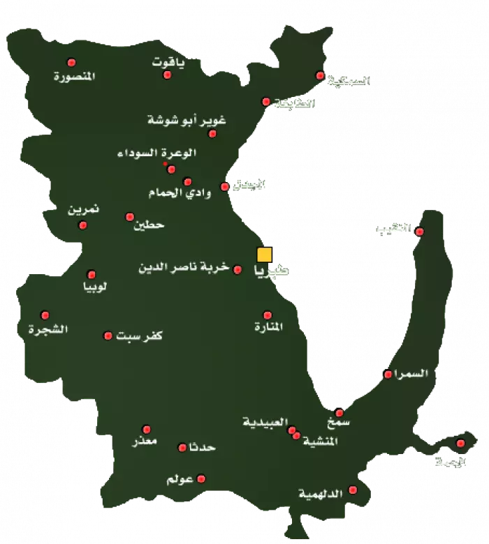
Al-Shajara lay amid the following Palestinian villages, towns, and lands:
- To the north and northwest: Tur'an.
- To the west: Kafr Kanna.
- To the south and southwest: agricultural and woodland areas extending towards Kafr Kama and the lands locally known as the Qabbaniyat.
- To the east: Kafr Sabt.
- To the northeast: Lubya.
Population of al-Shajara
The population of al-Shajara was recorded as 543 in 1922 and 584 in 1931. By 1945, it had reached 770 inhabitants, comprising 720 Muslims and 50 Christians. Based on demographic projections, the village population was approximately 890 in 1948.
Population of al-Shajara by Year
| Year | Population* |
|---|---|
| 1596 | Approximately 396 |
| Late nineteenth century | Approximately 150 |
| 1922 | 543 |
| 1931 | 584 |
| 1945 | 770 |
| 1948 | Approximately 890 |
| Estimated refugee population in 1998 | 5,485 |
* The figures for 1596, the late nineteenth century, 1948, and the refugee population in 1998 are estimates rather than contemporary census counts.
Number of Houses in al-Shajara
| Year | Number of houses |
|---|---|
| 1931 | 124 |
| 1948 | Approximately 189 |
* The 1948 figure is an estimate rather than a contemporary housing census.
Economic Life in al-Shajara
The inhabitants of al-Shajara depended principally on agriculture. The surrounding cultivable land supported cereal crops, fig trees, olive trees, and other orchards. A spring was situated to the south of the village, while woodland and fields of wild grass covered parts of the adjoining foothills.
According to the detailed 1944/45 land-use statistics, 2,142 dunams were devoted to cereal cultivation, including 2,102 dunams under Palestinian ownership, 28 dunams under Jewish ownership, and 12 dunams of public land. A further 577 dunams were irrigated or used for orchards.
Some secondary tables state that approximately 700 dunams were planted with olive trees. Since the official summary does not list olive groves as a separate land-use category, this figure should be understood as an overlapping estimate and should not be added separately to the cultivable-land total.
Land Ownership in al-Shajara
| Ownership category | Land area in dunams* |
|---|---|
| Palestinian ownership | 2,757 |
| Jewish ownership | 61 |
| Public land | 936 |
| Total | 3,754 |
* One dunam equals approximately 1,000 square metres.
Land Use in al-Shajara, 1944/45
| Land-use category | Palestinian ownership (dunams)* | Jewish ownership (dunams)* | Public land (dunams)* | Total (dunams)* |
|---|---|---|---|---|
| Cereal cultivation | 2,102 | 28 | 12 | 2,142 |
| Irrigated land and orchards | 544 | 33 | 0 | 577 |
| Built-up area | 100 | 0 | 0 | 100 |
| Cultivable land | 2,646 | 61 | 12 | 2,719 |
| Uncultivated land | 11 | 0 | 924 | 935 |
* One dunam equals approximately 1,000 square metres.
Archaeological Heritage of al-Shajara
Al-Shajara occupied an archaeological site containing the foundations of a ruined church, stones bearing inscriptions, and tombs cut into the rock. Two neighbouring khirbas, one to the northeast and the other to the southwest, contained architectural remains, cisterns, and burial grounds.
Occupation and Depopulation of al-Shajara
The military events connected with al-Shajara occurred in several stages:
The February Attack
In mid-February 1948, while fighting was taking place between Palestinian and Haganah forces in the Baysan Valley, the Haganah launched a diversionary attack on al-Shajara. The Palestinian newspaper Filastin reported that, shortly after midnight on 17 February, a Haganah unit entered the village and demolished two houses. A contemporary British communiqué described the two buildings as deserted.
The Occupation of 6 May 1948
After approximately six months of growing tension and armed confrontations in the surrounding area, news of the Deir Yasin massacre intensified fear among Palestinian communities. Oral accounts from al-Shajara state that women, children, and elderly residents were evacuated, while villagers capable of bearing arms remained to defend the village.
Accounts differ regarding the number of defenders and the size of the attacking force. Estimates of fifty to one hundred rifles among the defenders and approximately 1,500 attackers appear in oral narratives but have not been independently verified.
The Golani Brigade, principally its Twelfth or Barak Battalion, attacked al-Shajara at dawn on 6 May 1948. Another unit surrounded nearby Lubya to prevent reinforcements from reaching the village. Contemporary reporting stated that twenty Palestinian bodies were found after the village was overrun, although the precise number and circumstances of the deaths remain uncertain.
At approximately 8:00 a.m., Palestinian forces launched a counterattack from the direction of Kafr Kanna and Tur'an. The battle continued throughout the day, but al-Shajara remained under Haganah control by nightfall. The surviving inhabitants were displaced, and the village was subsequently largely destroyed.
The July Fighting near al-Shajara and Ilaniyya
Further fighting took place in the wider al-Shajara–Ilaniyya area between 8 and 13 July 1948. Arab Liberation Army units and Palestinian volunteers, including men from al-Shajara and neighbouring villages, attacked military positions around the nearby settlement of Ilaniyya, which had originally been named Sejera.
Some Palestinian oral narratives describe these engagements as the “liberation of al-Shajara.” The documentary record, however, does not conclusively establish that the depopulated Palestinian village was permanently recaptured. The accounts appear partly to combine fighting over the village site with the broader battle around nearby Ilaniyya and its military positions.
The Palestinian poet and fighter Abd al-Rahim Mahmoud was killed during these engagements on 13 July 1948 and was subsequently buried in al-Nasira.
The claim that 300 Palestinian and Arab fighters were killed during the July fighting could not be verified in the consulted academic and documentary sources. It should therefore not be presented as an established casualty figure.
The Final Military Situation
Some local narratives describe a counterattack on the night of 14 July as the final “fall” of al-Shajara. The best-documented chronology, however, places the village’s occupation and depopulation on 6 May 1948. The July events formed part of renewed fighting in the surrounding area rather than a separately documented initial occupation of the village.
Al-Shajara’s occupation, destruction, and the displacement of its Palestinian inhabitants formed part of Israel’s occupation of Palestine—the Nakba.
Israeli Settlements near al-Shajara
No Israeli settlement was established on the registered land of al-Shajara, according to the cadastral records presented by Walid Khalidi and the Institute for Palestine Studies.
The settlement of Sejera was established in 1902 northeast of the Palestinian village. Its name was taken from al-Shajara and was later changed to Ilaniyya, derived from a Hebrew word meaning “tree.” It was close to the village but was not established on its registered land.
Sde Ilan was established in 1949 east of al-Shajara’s agricultural lands, rather than directly on the village’s built-up site. The agricultural station known as Havat HaShomer was established nearby in 1956, but it too was outside the registered village lands.
Al-Shajara Today
- Ruins of Palestinian houses and broken steel bars protrude through the wild vegetation covering the village site. One side of an arched doorway remains standing.
- The western part of the site and the nearby hill are covered with cactus plants.
- Cattle barns belonging to the nearby settlement of Ilaniyya stand along the southern and eastern sides of the site.
- A wide, deep well with an internal spiral stairway remains visible at the northern edge of the village site.
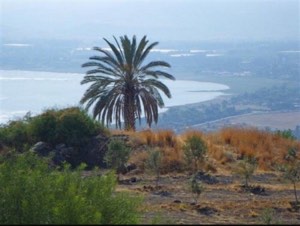
- Fig trees, doum palms, and chinaberry trees continue to grow in the area.
Sources
- Interactive Encyclopedia of the Palestine Question, “al-Shajara”, Institute for Palestine Studies.
- Walid Khalidi, ed., All That Remains: The Palestinian Villages Occupied and Depopulated by Israel in 1948, Institute for Palestine Studies, 1992.
- Palestine Remembered, “al-Shajara, Tiberias”.
- Sami Hadawi, Village Statistics 1945: A Classification of Land and Area Ownership in Palestine, Palestine Liberation Organization Research Centre.
- Government of Palestine, Village Statistics, April 1945, Department of Statistics and Department of Lands.
- Government of Palestine, Palestine: Report and General Abstracts of the Census of 1922.
- Government of Palestine, Census of Palestine, 1931: Population of Villages, Towns and Administrative Areas.
- 'Arif al-'Arif, Al-Nakba: Nakbat Bayt al-Maqdis wa-l-Firdaws al-Mafqud, 1947–1952.
Photo gallery


Photos from the village's people
Photos sent in by visitors and published after review.
Add a photo of this village
Log in to add photos of this village.
Other villages from Tiberias

 Download Our Palestine App
The whole archive in the palm of your hand: depopulated villages, the Nakba, the massacres and Al-Aqsa — free, with no ads to erase the story.
Download Our Palestine App
The whole archive in the palm of your hand: depopulated villages, the Nakba, the massacres and Al-Aqsa — free, with no ads to erase the story.



Comments
No comments yet — be the first to write one.
Add your comment
Name and email are optional. Comments appear after review.