
The depopulated village of Ma'alul / District of Nazareth

Ma'lul: History, Land, Depopulation, and the Village Today
Subdistrict: Nazareth
Population in 1944/45: 690
Estimated population in 1948: approximately 800
Date of occupation and depopulation: 14 or 15 July 1948; contemporary and later sources differ
Israeli settlements established on village land before the village's occupation: Nahalal was founded in 1921 on land sold from the Ma'lul estate; Timmorim was reportedly founded nearby in June 1948
Israeli settlements established on or partly on village land after 1948: Timrat and an Israeli military base
About Ma'lul
Ma'lul was a Palestinian village in the Nazareth Subdistrict, situated approximately 6 kilometres west of Nazareth.
The village stood on the northern edge of Wadi al-Mujaydil, facing the village of al-Mujaydil, approximately 2 kilometres to the south. Two springs lay near Ma'lul, one to the northeast and another to the northwest. A secondary road connected the village with the Nazareth–Haifa highway, which passed a short distance to the southeast.
Ma'lul may have occupied the site of an ancient settlement known as Mahalol, dating to the Roman period. The Crusaders later identified the locality as Maula. These historical identifications are probable rather than conclusively established.
Location and Surrounding Villages
Ma'lul lay among the following villages and localities:
- North: Ilut.
- South: Jabbata.
- Southeast: Al-Mujaydil.
These directions describe the village's broader geographical setting and should not be understood as a complete cadastral statement of every shared boundary.
Economic Life and the Land Question
At the beginning of the twentieth century, the villagers cultivated land owned by the Sursuq family of Beirut, a family of absentee landlords that had acquired the estate earlier. In 1921, the Sursuqs sold all but approximately 2,000 dunums of Ma'lul's land to the Palestine Land Development Company. Nahalal was founded that year on land acquired through this transaction.
Because the land remaining to the villagers was insufficient to sustain the community, the company agreed—at the request of the British Mandate government—to lease an additional 3,000 dunums to them until 1927, with an option to purchase. A prolonged legal dispute followed over ownership, tenancy, grazing rights, and whether the villagers had exercised that option. The Jewish National Fund ultimately obtained legal title to the disputed land and sought the villagers' eviction in 1945. Government-mediated negotiations continued into 1946 and 1947, but the proposed land exchange was not fully resolved before the end of the Mandate.
Agriculture was the principal source of livelihood. The villagers cultivated cereals and olives and pressed olive oil in a manually operated press. In 1944/45, 784 dunums of Palestinian-held land and 2,678 dunums of Jewish-held land were allocated to cereal cultivation. A further 650 dunums of Palestinian-held land were classified as irrigated land and orchards. The residents also raised livestock.
Land Ownership in Ma'lul, 1944/45
| Ownership Category | Area (Dunums) |
|---|---|
| Palestinian ownership | 1,949 |
| Jewish ownership | 2,719 |
| Public land | 30 |
| Total | 4,698 |
* One dunam equals approximately 1,000 square metres.
Land Use in Ma'lul, 1944/45
| Land-Use Category | Palestinian-Held Land (Dunums) | Jewish-Held Land (Dunums) |
|---|---|---|
| Irrigated land and orchards | 650 | 0 |
| Olive groves, reported separately | 700 | 0 |
| Cereal cultivation | 784 | 2,678 |
| Built-up area | 29 | 35 |
| Total cultivable land | 1,434 | 2,678 |
| Uncultivated land | 486 | 6 |
* One dunam equals approximately 1,000 square metres. The official aggregate classifies 650 dunums as irrigated land and orchards. A secondary tabulation reports 700 dunums of olive groves; because the categories appear to overlap or derive from different classifications, the olive figure is shown separately and is not added to the cultivable-land total. Public land accounts for a further 30 dunums of uncultivated land, bringing total uncultivated land to 522 dunums.
Architecture and Village Layout
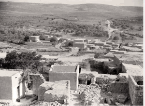
Ma'lul's houses were densely clustered. They were built from stone and mud, stone and cement, or concrete.
Population and Community Life
In 1944/45, Ma'lul had 690 residents: 490 Muslims and 200 Christians. The village contained one mosque and two churches, one Greek Orthodox and the other Greek Catholic. Residents obtained water for domestic use from nearby springs and wells.
Population of Ma'lul
| Year | Population | Status of Figure |
|---|---|---|
| 1596 | Approximately 77 | Estimate derived from Ottoman fiscal records |
| Late nineteenth century | Approximately 280 | Contemporary estimate |
| 1912 | 296 | Reported historical figure |
| 1922 | 436 | British Mandate census: 186 Muslims and 250 Christians |
| 1931 | 390 | British Mandate census |
| 1944/45 | 690 | Official village estimate: 490 Muslims and 200 Christians |
| 1948 | Approximately 800 | Retrospective demographic estimate, not a contemporaneous census count |
| Estimated refugees and descendants, 1998 | Approximately 4,915 | Retrospective demographic estimate, not an official census count |
Number of Houses in Ma'lul
| Year | Number of Houses | Status of Figure |
|---|---|---|
| 1931 | 90 | British Mandate census |
| 1948 | Approximately 184 | Retrospective estimate rather than a contemporaneous census count |
Archaeological Remains
During the late nineteenth century, a prominent Roman-period mausoleum known locally as Qasr al-Dayr stood just outside the village. Its remains provide evidence of settlement in the area during the Roman period. Traces of earlier building foundations and tombs were also recorded at the village site.
Occupation and Depopulation
Ma'lul was occupied during the second stage of Operation Dekel, as Israeli forces advanced toward Nazareth in July 1948. The precise date differs between accounts. Israeli historian Benny Morris places its occupation one day before the capture of Nazareth, indicating 15 July 1948, whereas a contemporary United Press report dated 15 July stated that Ma'lul had been occupied the previous day, indicating 14 July. The most historically responsible formulation is therefore that the village was occupied on 14 or 15 July 1948.
The operation in the area was conducted by Israeli forces, and the History of the Haganah attributes the occupation of Ma'lul and neighbouring Al-Mujaydil to a unit of the Golani Brigade. The villagers were displaced, and most of their houses were subsequently levelled. No verified casualty figure is provided by the principal sources consulted.
Israeli Settlements and Installations on Village Land
Nahalal was established in 1921 on land purchased from the Ma'lul estate, several kilometres west of the village site. Morris reports that Timmorim was established near Ma'lul in June 1948, before the village's occupation. The date suggests that it stood on land belonging to Ma'lul rather than on the village's built-up site. Timmorim was later transferred to a different location north of Qiryat Gat.
An agricultural training farm called Timrat operated near the village site during the 1950s, replacing the earlier Timmorim settlement, but it was later abandoned. Plans to re-establish Timrat were prepared in the late 1970s, and construction was completed in the early 1980s. PalQuest places Timrat approximately 1.5 kilometres west of the former village site and states that part of it stands on Ma'lul's land. An Israeli military base was also established on village land.
Kefar HaHoresh, founded in 1933, lies east of Ma'lul. Migdal HaEmek, founded in 1952 southwest of the village, was established primarily on land belonging to neighbouring Al-Mujaydil; it should therefore not be described without qualification as a settlement built on Ma'lul's village site.
Ma'lul Today
The former village site is largely covered by a pine forest planted by the Jewish National Fund and dedicated to various Jewish and non-Jewish figures. A military base also occupies part of the site.
The village mosque and its two churches remain standing. Historical surveys reported that these buildings were used intermittently as livestock shelters by residents of nearby Kefar HaHoresh. An Israeli plastics factory overlooks Wadi al-Halabi between the sites of Ma'lul and Al-Mujaydil. Cactus plants, olive trees, and fig trees grow among piles of stone and the remains of village houses. Several graves in the Muslim cemetery opposite the mosque also survive.
Sources
- Interactive Encyclopedia of the Palestine Question (PalQuest): Ma'lul
- Interactive Encyclopedia of the Palestine Question: Operation Dekel
- Palestine Remembered: Ma'lul, Nazareth Subdistrict
- Government of Palestine, Village Statistics, April 1945 (reproduced by Palestine Remembered)
- Government of Palestine census reports, including the 1922 and 1931 censuses
- Government of Palestine, Census of Palestine, 1931
- Institute for Palestine Studies: The Last Days of “Free Galilee”
Photo gallery


Photos from the village's people
Photos sent in by visitors and published after review.
Add a photo of this village
Log in to add photos of this village.
Other villages from Nazareth
 Download Our Palestine App
The whole archive in the palm of your hand: depopulated villages, the Nakba, the massacres and Al-Aqsa — free, with no ads to erase the story.
Download Our Palestine App
The whole archive in the palm of your hand: depopulated villages, the Nakba, the massacres and Al-Aqsa — free, with no ads to erase the story.



Comments
No comments yet — be the first to write one.
Add your comment
Name and email are optional. Comments appear after review.