
The depopulated village of Harrawi / District of Safed

About the depopulated village of Harrawi
- District
- Safed
- Date Harrawi was occupied
- 25 May 1948
- Population in 1948
- 290
- Military operation
- Operation Yiftach
- Brigade that carried it out
- Palmach
- Distance from the governorate centre
- 18 (km) North East of Safad
- Elevation above sea level
- 500 m
- Cause of displacement
- Military assault by Zionist troops
- Extent of destruction
- Harrawi was completely destroyed soon after occupation
- Ethnic cleansing
- Harrawi inhabitants were completely ethnically cleansed.
Hover a dot to read the village name, or click to open its card.
Borders of the depopulated village of Harrawi
Harrawi / 'Arab al-Hamdun – Safad Subdistrict
Harrawi, also known as 'Arab al-Hamdun and referred to in some Palestinian local sources as Khirbat Harrawi, was a depopulated Palestinian village in the Safad subdistrict. It stood on a mountain peak in eastern Upper Galilee overlooking the al-Hula Plain, approximately 18 km northeast of Safad and about 500 meters above sea level.
Its inhabitants belonged to the 'Arab al-Hamdun tribal community. Walid Khalidi describes them as Bedouin in origin and records that some continued to move during winter to lower lands adjoining the al-Hula Plain to graze their livestock, while the community also maintained permanent houses and cultivated land.
The official 1931 Census of Palestine recorded 148 inhabitants living in 36 houses. PalQuest's 1944/45 statistical table provides detailed land data but does not list an independent population figure for Harrawi that year. The registered village lands totaled 3,726 dunums.
Harrawi changed hands during Operation Yiftach in May 1948. Zionist forces had occupied the hills surrounding the village by 5 May, and Khalidi considers it probable that Harrawi itself was first occupied in mid-May. Arab forces later claimed to have retaken it. Palestinian summary sources give 25 May, the final day of Operation Yiftach, as the date of final occupation, but Khalidi does not independently establish that exact day for Harrawi itself.
Location of Harrawi
Harrawi stood on a mountain summit in eastern Upper Galilee overlooking the al-Hula Plain to the east.
A mountain track passed through the village toward the northwest and linked it with Qadas. Other unpaved tracks connected Harrawi with surrounding villages and pastoral areas.
Forests were extensive across the mountain landscape around the village.
Neighboring Villages and Areas
Palestinian local documentation describes Harrawi's geographical surroundings approximately as follows:
| Direction | Village / Area |
|---|---|
| North | al-Nabi Yusha' |
| Northeast | Baysamun |
| East | 'Arab al-Zubayd and Mallaha |
| South and southeast | 'Arab al-Zubayd |
| Southwest | Dayshum |
| West and northwest | Qadas |
These directions are useful for reconstructing the village's local setting, although original cadastral maps remain the strongest evidence for exact land boundaries.
The Name Harrawi and 'Arab al-Hamdun
The village name Harrawi was associated with an older khirba at the site, while the settlement was also widely known as 'Arab al-Hamdun after the community that lived there.
Later Palestinian local research associates the Hamdun with the broader 'Arab al-Muhammadat tribal grouping and records older seasonal movements between the al-Hula region, Mount 'Amil, and areas near the Palestine–Lebanon frontier.
Mustafa al-Dabbagh is also cited in local Palestinian documentation as proposing a possible Syriac origin for the place-name. This remains an etymological hypothesis rather than a conclusively established derivation.
Community and Seasonal Movement
Khalidi describes the villagers as descendants of the Bedouin 'Arab al-Hamdun tribe.
Some families continued to move during winter to the lower pastures adjoining the al-Hula Plain, where they grazed livestock.
The community was not exclusively nomadic, however: by 1931 it had 36 recorded houses, and its inhabitants also cultivated permanent agricultural land.
Built Environment
Harrawi's houses were clustered in a generally circular pattern, while more recent construction had begun to extend eastward.
The 1931 census recorded 36 houses.
Palestinian local documentation suggests a longer transition from tents and seasonal pastoral residence toward a more permanently settled village pattern during the Mandate period.
Population of Harrawi
| Year | Population | Nature of figure / Notes |
|---|---|---|
| 1922 | No verified independent figure | Harrawi / 'Arab al-Hamdun does not appear as a separately enumerated locality in the sources reviewed for the 1922 census |
| 1931 | 148 | Official Census of Palestine; all recorded inhabitants were Muslims |
| 1944/45 | No separate figure shown | PalQuest's official statistical table provides land figures but does not list an independent Harrawi population figure for 1945 |
| 1948 | 290 | Later Palestine Remembered estimate; not an official Government of Palestine census |
| 1998 | 1,781 refugees and descendants | Later demographic estimate published by Palestine Remembered |
Number of Houses
- 193136Official Census of Palestine; the locality was listed under 'Arab al-Hamdun
No securely documented independent 1948 house estimate was found in the core sources reviewed.
Land Ownership in 1944/45
Harrawi's registered lands totaled 3,726 dunums.
Using Palestine Remembered's simplified terminology:
- Palestinian2,255 dunums61%
- Transferred to Zionists1,471 dunums39%
- Communal/Public0 dunums0%
The official categories record the same figures as 2,255 Arab dunums and 1,471 Jewish dunums, with no Public land.
Land Use in 1944/45
- Arab
- Jewish
- Cereals881 dunums
- Built-up land2 dunums
- Non-cultivable land2,843 dunums
The land-use totals balance exactly with the official ownership figures.
The recording of zero Arab dunums in the official “built-up” land category should not be interpreted as meaning that the Palestinian inhabitants had no houses. The 1931 census independently recorded 36 houses. The built-up category was a cadastral land-use classification rather than a dwelling count.
Economic Life in Harrawi
Livestock raising was traditionally central to the economy of 'Arab al-Hamdun.
Sheep, goats, cattle, and camels formed an important part of village livelihoods, while the surrounding mountain forests and seasonal pastures of the al-Hula Plain supported pastoral activity.
Agriculture became increasingly important as the community became more permanently settled. In 1944/45, 551 Arab dunums were devoted to cereal cultivation.
Palestinian local sources identify wheat, barley, and maize among the crops and state that household surpluses were sold in neighboring villages and towns.
Livestock
Palestinian community documentation records sheep, goats, cattle, camels, horses, and poultry among the animals kept by Harrawi families.
Dairy products, clarified butter, eggs, and other animal products were used locally and surpluses were traded outside the village.
Horses and camels also served as means of transport.
Water Sources
Local Palestinian documentation describes Harrawi's lands as relatively rich in springs and seasonal water sources.
Wadi 'Arus passed east of the village toward the al-Hula basin, while springs were particularly numerous to the west.
A spring south of the village reportedly attracted a cluster of houses and provided water for domestic use, livestock, and some cultivation.
These details derive from later Palestinian local documentation; Khalidi's core village entry does not provide a complete list of the village's named water sources.
Education and Public Services
No independent school is securely documented in Harrawi.
Palestinian local documentation states that boys from the village attended the elementary school in Mallaha.
The same source records no independent clinic, administrative building, mosque, or commercial center inside the village, with residents relying on surrounding communities for many services and purchases.
Religious Life
The inhabitants recorded in the 1931 census were Muslims.
Neither Khalidi nor the Palestinian local sources used here securely document an independent mosque or named shrine within Harrawi itself.
No religious building has therefore been added without supporting evidence.
Archaeological Remains
Khirbat Harrawi contained substantial archaeological evidence of earlier occupation, especially from the Byzantine period.
Khalidi records old wall foundations, tessellated mosaic floors, a wine press, and stones bearing Greek inscriptions.
Palestinian local research additionally lists caves, rock-cut tombs, cisterns, ruined walls, and building foundations.
These remains demonstrate the antiquity of occupation at the site but do not prove uninterrupted population continuity between the Byzantine settlement and the modern Palestinian village.
The 12 February 1948 Ambush
Military violence reached the Harrawi area several months before its final depopulation.
On 12 February 1948, an Arab bus traveling from the al-Hula region toward Safad was ambushed near Harrawi by a Zionist unit.
A mine exploded beneath the bus, after which the passengers were fired upon and incendiary grenades were thrown. Four people were killed.
Operation Yiftach
Operation Yiftach ran from 15 April to 25 May 1948.
It was a Palmach campaign designed to establish Zionist control over eastern Galilee, Safad, the al-Hula region, and the northern approaches before and immediately after the end of the British Mandate.
The Palmach's First Battalion served as the spearhead of the operation.
Operation Yiftach combined direct military assaults with psychological warfare, and after Safad fell on 11 May participating units moved northward toward the Lebanese and Syrian approaches.
PalQuest explicitly lists Harrawi among the villages affected by the operation.
Occupation of the Surrounding Hills – 5 May 1948
On 5 May 1948, Arab Liberation Army commander Fawzi al-Qawuqji reported that Zionist forces had occupied all the hills surrounding Harrawi.
The Arab Liberation Army's Second Yarmuk Regiment, commanded by Adib al-Shishakli, was responsible for the defense of the area.
The capture of the surrounding hills does not establish that Harrawi itself was permanently occupied on 5 May, because later evidence shows that control continued to change.
Probable First Occupation in Mid-May
Khalidi considers it probable that Harrawi itself was occupied in mid-May 1948.
The reasoning is that Arab forces subsequently claimed to have retaken the village following the entry of the Arab armies into Palestine.
Harrawi's military history therefore cannot be reduced to a single occupation date.
Reported Arab Recapture around 17 May
The New York Times, citing a report from Damascus dated 17 May, stated that Lebanese soldiers and Arab irregular fighters supported by Syrian aircraft claimed victory at Harrawi and nearby al-Malikiyya.
This suggests that Harrawi or its immediate position returned to Arab control temporarily.
Khalidi, however, considers it unlikely that the village remained in Arab hands for long as Zionist forces resumed their advance across the area.
Final Occupation of Harrawi
Palestine Remembered and the Palestinian Villages Encyclopedia give 25 May 1948 as Harrawi's final occupation date.
This coincides with the final day of Operation Yiftach and with the fall of nearby Mallaha and Baysamun.
Khalidi, however, does not explicitly state that Harrawi itself was captured on 25 May. He concludes only that it probably did not remain in Arab hands for long after the reported recapture.
The most accurate formulation is therefore that final Israeli control over Harrawi was probably consolidated by the end of Operation Yiftach on 25 May 1948, while the exact village-specific day of final occupation remains uncertain.
Military Unit
Harrawi fell within Operation Yiftach, which was carried out by Palmach forces, with the Palmach's First Battalion serving as the operation's spearhead.
Palestine Remembered identifies the First Battalion as the attacking unit.
Khalidi's Harrawi-specific narrative, however, does not identify the exact battalion or company responsible for every stage of the village's changing control.
The most precise formulation is therefore: Palmach forces during Operation Yiftach, with the First Battalion serving as the operation's spearhead.
Arab Defenders
The Second Yarmuk Regiment of the Arab Liberation Army, under Adib al-Shishakli, was responsible for defending the Harrawi area in early May.
After 15 May, Lebanese soldiers and Arab irregulars, reportedly supported by Syrian aircraft, participated in fighting around Harrawi and al-Malikiyya.
The village's military history was thus part of the broader struggle along the Palestine–Lebanon frontier rather than a single isolated village assault.
Occupation Chronology
- 12 February 1948
Ambush near Harrawi
An Arab bus traveling from al-Hula to Safad was ambushed near the village; four people were killed.
- 15 April 1948
Beginning of Operation Yiftach
Palmach forces began their campaign to take eastern Galilee, Safad, and the al-Hula region.
- By 5 May 1948
Occupation of surrounding hills
Fawzi al-Qawuqji reported that Zionist forces had occupied all the hills around Harrawi; the Second Yarmuk Regiment was responsible for defending the sector.
- Mid-May 1948
Probable first occupation
Khalidi considers this the likely period in which Harrawi itself was first occupied, although the exact date is unknown.
- Around 17 May 1948
Reported Arab recapture
A report from Damascus claimed that Lebanese troops and Arab irregulars supported by Syrian aircraft achieved a victory at Harrawi and al-Malikiyya.
- Second half of May 1948
Renewed change in control
Khalidi considers it unlikely that Harrawi remained in Arab hands for long as Operation Yiftach continued.
- 25 May 1948
Fall of Mallaha and Baysamun
The neighboring villages fell at the end of Operation Yiftach, strongly suggesting consolidated Zionist control over Harrawi by the same period.
- 25 May 1948
Indexed final occupation date
Used by Palestine Remembered and Palestinian local reference works, but best treated as the probable date of final consolidation rather than an independently established exact capture day.
- Later; exact date not documented
Destruction of the village
The built-up village was destroyed and no visible village structure remained during the later field survey.
Refugees from Harrawi
Palestine Remembered estimates Harrawi's population in 1948 at approximately 290. This is a later demographic estimate rather than an official Government of Palestine census figure.
The same source estimates that Harrawi refugees and their descendants numbered approximately 1,781 in 1998.
Palestinian local documentation states that most villagers took refuge in Lebanon, while a small number remained inside Palestine after the Nakba. This is community documentation rather than a comprehensive official refugee census.
Israeli Settlements on Harrawi Village Lands
Walid Khalidi and PalQuest state that no Israeli settlement was originally established on Harrawi's village lands.
| Settlement | Established | Relationship to Harrawi |
|---|---|---|
| Ramot Naftali | 1945 | Established north/northeast of Harrawi on the lands of neighboring al-Nabi Yusha', not originally on Harrawi land according to Khalidi |
The Palestinian Villages Encyclopedia states that parts of Harrawi's land were later incorporated into Ramot Naftali.
These two statements are not necessarily contradictory: the settlement was not originally founded on Harrawi land, but later expansion or incorporation may have included former Harrawi land. Determining the exact extent requires original cadastral records.
Harrawi Today
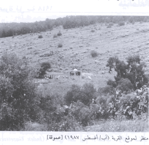
In Walid Khalidi's field description, no visible trace of the former village structures remained.
Forest covered the mountain summit on which Harrawi had stood and much of its slopes. Other parts of the village lands had also become woodland, while fruit trees had been planted in some areas.
This description does not constitute direct field verification of conditions in 2026. Field research for All That Remains was carried out between 1987 and 1990, before the book's publication in 1992.
Palestine Remembered and Palestinian community sources contain later photographs and visits showing rubble and traces at parts of the site. These materials are valuable for documenting memory and subsequent landscape change but do not constitute a comprehensive contemporary survey of all former Harrawi lands.
Sources
- PalQuestPalQuest – Harrawi
- PalQuestPalQuest – Operation Yiftach
- Palestine RememberedPalestine Remembered – Harrawi / 'Arab al-Hamdun, Safad District
- Palestine RememberedPalestine Remembered – Harrawi entry from Walid Khalidi's All That Remains
- Institute for Palestine StudiesInstitute for Palestine Studies – Walid Khalidi, All That Remains
- palqura.comPalestinian Villages Encyclopedia – Harrawi / Khirbat Harrawi / 'Arab al-Hamdun; supplementary local documentation
- PalQuestPalQuest – All That Remains: Methodology and Field Research
Photo gallery


Photos from the village's people
Photos sent in by visitors and published after review.
Add a photo of this village
Log in to add photos of this village.
Other villages from Safed
More from the archive



 Download Our Palestine App
The whole archive in the palm of your hand: depopulated villages, the Nakba, the massacres and Al-Aqsa — free, with no ads to erase the story.
Download Our Palestine App
The whole archive in the palm of your hand: depopulated villages, the Nakba, the massacres and Al-Aqsa — free, with no ads to erase the story.



Comments
No comments yet — be the first to write one.
Add your comment
Name and email are optional. Comments appear after review.