
The depopulated village of Karatiyya / District of Gaza
Subdistrict: Gaza
Population in 1948: Approximately 1,589
Date of occupation and depopulation: Night of 17–18 July 1948
Military operation: Operation An-Far / Operation Death to the Invader
Attacking forces: The 89th Mechanized Battalion of the 8th Armoured Brigade, supported by the 3rd Battalion of the Givati Brigade
Settlements established on village land before 1948: None
Settlements established on village land after 1948: Komemiyut, Revaha, and part of Nehora
Settlements established on the original built-up village site: None conclusively documented
Karatiyya was a Palestinian village in the Gaza Subdistrict, situated approximately 29 kilometres northeast of Gaza and about one kilometre northwest of al-Faluja. It stood near the al-Faluja–al-Majdal road and was surrounded by the villages of Hatta, ‘Iraq Suwaydan, and Bayt ‘Affa.
The village stood on generally level ground in Palestine’s southern coastal plain, at an elevation of approximately 100 metres above sea level. Wadi al-Mufrid, which flowed from the direction of al-Faluja, passed along its southern and western edges. This natural feature restricted the village’s expansion in those directions.
Boundaries of Karatiyya
Karatiyya was bordered by the following villages and localities:
- Northwest: Bayt ‘Affa.
- West: ‘Iraq Suwaydan.
- Southwest: Hulayqat.
- South: lands used by Bedouin communities associated with the Beersheba region.
- Southeast: al-Faluja.
- East: Zayta.
- Northeast: Hatta.
Area of Karatiyya
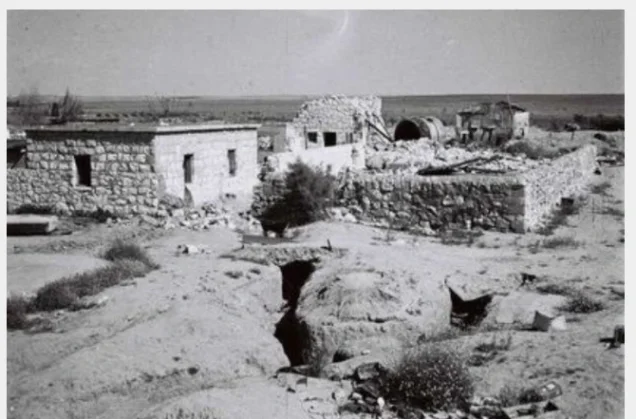
The village’s built-up area occupied approximately 48 dunams. Its houses were constructed primarily of adobe brick. Architectural expansion proceeded mainly towards the north, influenced by the course of the al-Majdal–al-Faluja road and by Wadi al-Mufrid, which constrained development to the south and west.
Karatiyya’s total land area amounted to 13,709 dunams, of which 13,346 dunams were privately owned by Palestinians and 363 dunams were classified as public land.
Architecture of Karatiyya
The houses were built mainly of adobe and extended in parallel with the road connecting al-Faluja and al-Majdal. Karatiyya depended on the nearby town of al-Faluja for many medical, commercial, administrative, and educational services.
The village nevertheless maintained several local facilities, including a mosque, an elementary school, two wells, and a grain mill.
Population of Karatiyya
Karatiyya had a population of 736 in 1922. The number rose to 932 in 1931 and 1,370 in 1945. The estimated population at the time of the Nakba was approximately 1,589.
Population Figures for Karatiyya
| Year | Population* |
|---|---|
| 1596 | 253 |
| 1922 | 736 |
| 1931 | 932 |
| 1945 | 1,370 |
| 1948 estimate | 1,589 |
| Estimated number of refugees in 1998 | 9,759 |
* The figures for 1948 and 1998 are demographic estimates rather than contemporary census counts.
Number of Houses in Karatiyya
| Year | Number of houses |
|---|---|
| 1931 | 229 |
| 1948 estimate | 390 |
Economic Life in Karatiyya
Two wells dug within the village supplied water for domestic use. Rain-fed agriculture formed the basis of the local economy, and cereals were the principal crop. In 1944/45, approximately 12,928 dunams were devoted to cereals, while 321 dunams were irrigated or used for orchards.
Fruit trees occupied a comparatively small area on the eve of the Nakba. The village also had a grain mill, while some residents raised livestock alongside their agricultural work.
Land Ownership in Karatiyya
| Ownership category | Area (dunams)* |
|---|---|
| Palestinian-owned | 13,346 |
| Jewish-owned | 0 |
| Public land | 363 |
| Total | 13,709 |
* One dunam equals approximately 1,000 square metres.
Land Use in Karatiyya in 1945
| Type of land use | Palestinian land (dunams)* |
|---|---|
| Irrigated land and orchards | 321 |
| Cereal cultivation | 12,928 |
| Built-up area | 48 |
| Cultivable land | 13,249 |
| Uncultivable land | 412 |
* One dunam equals approximately 1,000 square metres.
Education in Karatiyya
Karatiyya had an elementary school established in 1922. Its enrolment reached 128 pupils in the mid-1940s. The village also maintained a mosque, although residents continued to depend on nearby al-Faluja for many advanced educational and administrative services.
Archaeological Remains in Karatiyya
The village lands contained several ruined sites associated in published descriptions with the Crusader and Mamluk periods. Karatiyya also had a grain mill. However, the linguistic claim that the village’s name was Greek and meant “strength” is not firmly supported.
E. H. Palmer associated the name with thick or tangled vegetation. Because the etymology remains uncertain, it is preferable not to present either interpretation as conclusively established.
Occupation and Depopulation of Karatiyya
Karatiyya was attacked months before its final occupation. On the night of 9 December 1947, a Haganah unit demolished at least one house in the village; the operational order had reportedly called for the destruction of two houses.
The village was finally occupied on the night of 17–18 July 1948, during the Ten Days of fighting between the first and second truces. The assault formed part of the operation commonly known as Operation Death to the Invader, which followed Operation An-Far and sought to open a corridor towards the Negev.
The principal assault was carried out by the 89th Mechanized Battalion of the 8th Armoured Brigade, with support from the 3rd Battalion of the Givati Brigade. The mechanized battalion entered and occupied the village, after which a Givati infantry company remained to hold it.
Benny Morris records that Karatiyya came under machine-gun fire and that its inhabitants abandoned the village. Egyptian forces subsequently counterattacked and reached its outskirts. A sustained battle followed, but the attacking Egyptian force did not recapture the village.
Settlements Established on the Land of Karatiyya
Three settlements are documented as standing wholly or partly on Karatiyya’s land:
- Komemiyut, established in 1950.
- Revaha, established in 1953 near the village site.
- Nehora, established in the mid-1950s partly on Karatiyya’s land and partly on land belonging to al-Faluja.
Shahar is located in the wider region but is not listed by Walid Khalidi among the settlements established on Karatiyya’s land. It should therefore not be included without parcel-level cadastral evidence.
None of these settlements is conclusively documented as occupying the original 48-dunam built-up centre itself. It is more accurate to describe them as established on village land or near the former village site.
Karatiyya Today
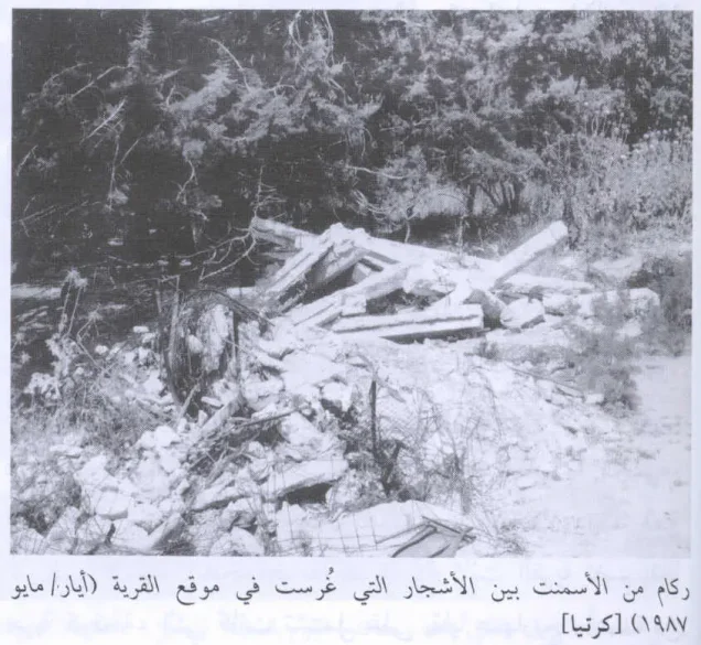
Piles of rubble are scattered across the village site. A ruined cemetery, partly concealed among eucalyptus trees, remains visible, and an agricultural road crosses the area.
Farmers from the surrounding settlements cultivate cereals and alfalfa on the former village site and its neighbouring lands.
Sources
- PalQuest: Karatiyya.
- PalQuest: Photograph of Karatiyya’s remains, May 1987.
- Palestine Remembered: Karatiyya, Gaza Subdistrict.
- Institute for Palestine Studies: All That Remains.
- Walid Khalidi, ed., All That Remains, Institute for Palestine Studies, 1992.
- Government of Palestine, Department of Statistics, Village Statistics, April 1945.
- Government of Palestine, Census of Palestine, 1922 and Census of Palestine, 1931.
- Benny Morris, The Birth of the Palestinian Refugee Problem Revisited, Cambridge University Press, 2004.
Photo gallery
Photos from the village's people
Photos sent in by visitors and published after review.
Add a photo of this village
Log in to add photos of this village.
Other villages from Gaza
 Download Our Palestine App
The whole archive in the palm of your hand: depopulated villages, the Nakba, the massacres and Al-Aqsa — free, with no ads to erase the story.
Download Our Palestine App
The whole archive in the palm of your hand: depopulated villages, the Nakba, the massacres and Al-Aqsa — free, with no ads to erase the story.



Comments
No comments yet — be the first to write one.
Add your comment
Name and email are optional. Comments appear after review.