
The depopulated village of Samakh / District of Tiberias

Subdistrict: Tiberias
Estimated Palestinian population in 1948: approximately 4,014
Initial occupation and depopulation: 28 April 1948; some summaries give 27 April
Final Israeli reoccupation: 21 May 1948, following a brief period of Syrian control
Military unit: Golani Brigade; a Yiftach Brigade assault during the intervening battles did not capture the town
Israeli settlements established on or later expanded onto Samakh’s lands before 1948: Massada and Sha'ar HaGolan, established in 1937
Israeli settlements established on Samakh’s village site or lands after 1948: Ma'agan and Tel Qatzir, both established in 1949
Samakh
Samakh was a major Palestinian town in the Tiberias Subdistrict, situated approximately 10 kilometres southeast of Tiberias. It stood on level ground in the Jordan Valley at the southernmost shore of Lake Tiberias, a short distance east of the point where the Jordan River flows out of the lake.
Samakh was the largest Palestinian locality in the Tiberias Subdistrict in terms of both population and cadastral area. Its location made it an important transportation centre connecting the regions east and west of the Jordan River, the communities around Lake Tiberias, and the Jordan Valley to the south.
The town had a railway station on the line connecting Haifa with the Hijaz Railway. A principal road ran along the lakeshore and linked Samakh with Tiberias to the northwest, while boat routes across Lake Tiberias connected it with the port of Tiberias.
The statement that 8,500 people were expelled from Samakh is not supported by the British Mandate statistics or the principal Palestinian academic sources. The town had 3,460 Palestinian residents in 1945, while its 1948 population is retrospectively estimated at approximately 4,014.
Boundaries of Samakh
Samakh lay among the following Palestinian villages, towns, and geographical features:
- North: Lake Tiberias.
- Northwest: al-Manara.
- West: al-Ubaydiyya.
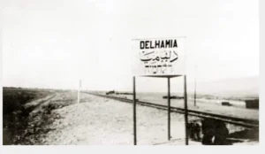
- South: al-Dalhamiyya.
- Southwest: al-Hamma.
- East and northeast: al-Samra and the lands extending towards the Golan.
The original list repeated “northwest” for al-Samra. Its direction has been corrected to east and northeast in accordance with the relative geographical positions of the localities.
The Name and Historical Origins of Samakh
Samakh’s Arabic name has been associated in local linguistic accounts with the emergence or first growth of cultivated plants. Other interpretations of the name also appear in historical and geographical literature, and its precise etymology cannot be treated as conclusively established.
The Palestinian town was founded in the early nineteenth century on the remains of an earlier settlement known as Kefar Semah, which had been inhabited during the Roman period. It is therefore inaccurate to state categorically that the town was known as “Kfar Samah” during the Canaanite period.
Samakh retained its Arabic name throughout the Ottoman and British Mandate periods. Massada was the name of a separate settlement established southeast of the town in 1937; it was not a replacement name imposed on Samakh after 1948.
Most of Samakh’s houses were built of adobe, while some were constructed from the black basalt stone widely available in the surrounding region. In 1812, the Swiss traveller Johann Ludwig Burckhardt described it as a settlement of approximately thirty or forty mud houses, alongside several more substantial buildings made of black stone.
Population of Samakh
The British census of 1922 recorded 976 residents. The 1931 census recorded an Arab population of approximately 1,860, while the wider statistical unit had a total population of 1,909. The figure of 1,865 appearing in some compilations reflects a discrepancy between transcriptions and should not be presented without qualification.
In 1945, Samakh had 3,460 Palestinian residents: 3,320 Muslims, 130 Christians, and ten people recorded under other religious categories. A large proportion of the population belonged to the settled Palestinian Bedouin communities of Arab al-Suqur and Arab al-Bashatiwa. These communities had settled in and around Samakh before 1945; they did not first arrive in that year.
The population immediately before the Nakba has been retrospectively estimated at approximately 4,014. Another demographic projection estimated that refugees from Samakh and their descendants numbered approximately 24,648 in 1998. These two figures are estimates rather than contemporaneous census counts.
Population Record for Samakh
| Year | Recorded or estimated population | Notes |
|---|---|---|
| 1922 | 976 | British Mandate census. |
| 1931 | Approximately 1,860 Palestinians | The wider statistical unit recorded a total of 1,909; estimates vary slightly between transcriptions. |
| 1945 | 3,460 Palestinians | British Mandate village statistics. |
| 1948 | Approximately 4,014 Palestinians | Retrospective demographic estimate, commonly rounded to 4,010. |
| 1998 | Approximately 24,648 refugees and descendants | Retrospective demographic projection, not a census count. |
Number of Houses in Samakh
| Year | Number of houses | Nature of figure |
|---|---|---|
| 1931 | 480 | Recorded in the British Mandate census for the statistical locality. |
| 1948 | Approximately 1,009 | Retrospective estimate; no contemporaneous 1948 housing census has been identified. |
The Local Council of Samakh
Samakh’s local council was established in 1923. Its expenditure increased steadily as the town developed, rising from 310 Palestinian pounds in 1929 to 1,111 Palestinian pounds in 1944.
The existence of the council, railway station, schools, commercial activity, and specialised occupations reflected Samakh’s importance as an administrative and transportation centre in the southern part of the Tiberias Subdistrict.
Education in Samakh
Samakh had two schools, one for boys and another for girls. Local Palestinian accounts trace their origins to the late Ottoman period, while both continued serving the town during the British Mandate.
Palestinian biographical accounts identify Falah al-Madi as the final headmaster of the boys’ school. He later became a judge and served as secretary and a member of the first Executive Committee of the Palestine Liberation Organization in 1964.
Economic Life in Samakh
Samakh’s residents depended primarily on agriculture, commerce, transportation, and service occupations. Grain and bananas were among the principal crops. During the 1944/45 agricultural year, Palestinians cultivated approximately 8,523 dunams with cereals.
The town’s location on the railway, the lakeshore road, and regional routes allowed its residents to work in trade, transport, fishing, railway services, and various crafts. Its economy was therefore more diversified than that of many smaller agricultural villages in the subdistrict.
Land Ownership in Samakh, 1944/45
| Ownership category | Area (dunams)* |
|---|---|
| Palestinian ownership | 9,265 |
| Jewish ownership | 8,412 |
| Public land | 934 |
| Total | 18,611 |
* One dunam equals approximately 1,000 square metres.
The Mandate statistical unit for Samakh included Massada and Sha'ar HaGolan. The Jewish-ownership and land-use figures must therefore be read in relation to this combined statistical unit.
Land Use in Samakh, 1944/45
| Land-use category | Palestinian-owned land (dunams)* | Jewish-owned land (dunams)* | Public land (dunams)* | Total (dunams)* |
|---|---|---|---|---|
| Citrus and banana cultivation | 0 | 264 | 0 | 264 |
| Irrigated land and orchards | 0 | 243 | 0 | 243 |
| Cereal cultivation | 8,523 | 7,814 | 55 | 16,392 |
| Built-up area | 239 | 91 | 22 | 352 |
| Total cultivable land | 8,523 | 8,321 | 55 | 16,899 |
| Uncultivated land | 503 | 0 | 857 | 1,360 |
| Total cadastral area | 9,265 | 8,412 | 934 | 18,611 |
* One dunam equals approximately 1,000 square metres.
The figures include the Mandate statistical localities of Massada and Sha'ar HaGolan. The original table incorrectly listed 8,578 Palestinian-owned dunams under cereal cultivation and 261 dunams as Palestinian built-up land; the verified figures are 8,523 and 239 dunams respectively.
Occupation and Depopulation of Samakh
Samakh’s occupation occurred through several distinct stages during the Nakba. After Zionist forces occupied Tiberias on 18 April 1948, Samakh became increasingly isolated from the rest of Palestine. Its remaining connection ran through al-Hamma towards Syria and Transjordan.
The Golani Brigade subsequently prepared to occupy Samakh. Palestinian and academic sources indicate that the police station was occupied on 28 April 1948 and that the town’s Palestinian residents were displaced at approximately the same time. Some compilations give 27 April, but 28 April is the date recorded in the principal Palestinian academic synthesis. Estimates therefore vary by one day.
Syrian forces, assisted by Iraqi troops, regained Samakh briefly in mid-May. Sources differ on whether this occurred on 16 or 18 May. A later attack by the Yiftach Brigade caused heavy losses among the Syrian defenders but did not immediately capture the town.
Following artillery fire and aerial attacks against Syrian positions around Samakh, the Syrian forces withdrew. Units of the Golani Brigade re-entered the town on the morning of 21 May 1948. Fighting and air attacks in the surrounding area reportedly continued for several more days.
Accordingly, 28 April should be identified as the date of the initial occupation and depopulation, while 21 May marks the final Israeli reoccupation after the brief Syrian recovery of the town. The claim that all 8,500 residents were displaced in May is incorrect; the verified Palestinian population was substantially lower.
Israeli Settlements on Samakh’s Lands
- Massada and Sha'ar HaGolan were established southeast of the village site in 1937 and later expanded onto land belonging to Samakh.
- Ma'agan was established on the former village site in 1949, not in 1947.
- Tel Qatzir was established on Samakh’s lands in 1949.
- Deganya Alef, founded in 1909, and Deganya Bet, founded in 1920, are close to Samakh but were not established on its cadastral land.
Samakh Today
The principal surviving landmarks of Samakh are the ruins of its railway station and a water reservoir. A public park, petrol station, industrial facilities, and other buildings were subsequently constructed on parts of the village site. The surrounding Palestinian lands are cultivated.
Sources
- PalQuest: Samakh — location, population, land, occupation, settlements, and present condition.
- Institute for Palestine Studies: Samakh Village.
- Institute for Palestine Studies: Walid Khalidi, All That Remains.
- Palestine Remembered: Samakh, Tiberias Subdistrict.
- Sami Hadawi, Village Statistics of 1945: A Classification of Land and Area Ownership in Palestine.
- Walid Khalidi, All That Remains, Institute for Palestine Studies, 1992.
Photo gallery


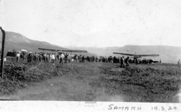


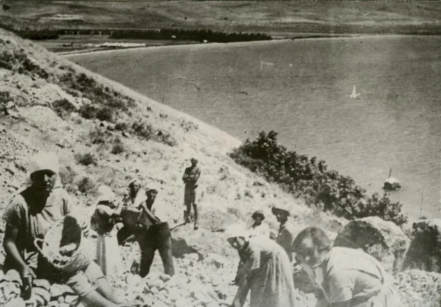


Photos from the village's people
Photos sent in by visitors and published after review.
Add a photo of this village
Log in to add photos of this village.
Other villages from Tiberias
 Download Our Palestine App
The whole archive in the palm of your hand: depopulated villages, the Nakba, the massacres and Al-Aqsa — free, with no ads to erase the story.
Download Our Palestine App
The whole archive in the palm of your hand: depopulated villages, the Nakba, the massacres and Al-Aqsa — free, with no ads to erase the story.



Comments
No comments yet — be the first to write one.
Add your comment
Name and email are optional. Comments appear after review.