
The depopulated village of Al-Damun / District of Akka (Acre)
Subdistrict: Acre
Estimated population of al-Damun in 1948: 1,520
Date of occupation and depopulation: Probably 15–16 July 1948
Military operation: Operation Dekel
Military unit: Sheva‘ (Seventh) Brigade
Israeli settlements established on al-Damun’s lands after 1948: None
Al-Damun was a Palestinian village in the Acre Subdistrict, situated approximately 11.5 km southeast of Acre. Its population immediately before the Nakba has been estimated at approximately 1,520. Israeli forces occupied and depopulated the village in 1948, after which its built environment was almost entirely destroyed.
The village extended across the flat summit and slopes of a rocky hill at the eastern edge of the Acre plain, at an average elevation of approximately 35 metres. Secondary roads connected it with the Acre–Safad and Acre–Haifa highways. Al-Damun had an elementary school, a mosque, and a Christian community with its own church. Springs provided drinking water, while water from the Na‘amin River was used to irrigate some crops.
Wheat, sorghum, barley, olives, watermelons, and cantaloupes were among the village’s principal crops. Olive cultivation was particularly important. Residents also produced mats and baskets from esparto grass and rushes growing along the riverbanks.
Boundaries of al-Damun
Al-Damun was situated near the following villages, localities, and geographical areas:
- North: al-Birwa.
- Northeast: Sha‘b.
- East: Kabul.
- South: Tamra.
- West and southwest: the lands of al-Qabaniyyat and the Na‘amin River area.
- Northwest: Acre and the western Acre plain.
The directional descriptions in the original text contained duplicated and geographically inconsistent entries. They have been reorganized according to the village’s documented location and neighbouring localities.
Population of al-Damun
At the time of the 1922 census of Palestine, al-Damun had 727 inhabitants: 687 Muslims and 40 Christians. The Christian residents were recorded as Greek Catholics.
By the 1931 census, the population had increased to 917, comprising 870 Muslims and 47 Christians living in 183 houses. In 1945, the village population was estimated at 1,310: 1,240 Muslims and 70 Christians.
The figure of 1,520 for 1948 is a later demographic projection rather than an official census count.
Population of al-Damun
| Year | Population* |
|---|---|
| 1859 estimate | Approximately 800 |
| 1922 | 727 |
| 1931 | 917 |
| 1945 | 1,310 |
| 1948 estimate | 1,520 |
| Estimated number of refugees in 1998 | 9,332 |
*The figures for 1948 and 1998 are later demographic estimates, not contemporary census counts. The nineteenth-century figure is also an estimate.
Number of Houses in al-Damun
| Year | Number of houses |
|---|---|
| 1931 | 183 |
| 1948 estimate | 303 |
*The 1931 figure is documented in the official census, whereas the 1948 figure is a later estimate.
The Lands of al-Damun
According to the official 1944/45 village statistics, al-Damun’s lands covered 20,357 dunums. Of this total, 709 dunums were irrigated or used for orchards, 17,052 dunums were planted with cereals, and 111 dunums constituted the built-up area.
The cereal figure comprised 16,368 dunums of Palestinian Arab-owned land and 684 dunums of Jewish-owned land. Similarly, the 709 dunums of irrigated land and orchards comprised 706 Arab-owned dunums and 3 Jewish-owned dunums.
Land Ownership in al-Damun
| Ownership category | Land ownership in dunums* |
|---|---|
| Palestinian Arab-owned | 19,073 |
| Jewish-owned | 687 |
| Public land | 597 |
| Total | 20,357 |
*One dunum is equivalent to approximately 1,000 square metres. “Public land” follows the classification used in the official village statistics and should not be confused with private communal ownership.
Land Use in al-Damun in 1944/45
| Land-use category | Palestinian Arab-owned land in dunums* | Jewish-owned land in dunums* |
|---|---|---|
| Irrigated land and orchards | 706 | 3 |
| Land planted with olive trees, included within the orchard category | 484 | 0 |
| Land planted with cereals | 16,368 | 684 |
| Built-up area | 111 | 0 |
| Total cultivable land | 17,074 | 687 |
| Non-cultivable land | 2,485 | 0 |
*One dunum is equivalent to approximately 1,000 square metres. The olive-growing area was included within the irrigated-land and orchard category and should not be added to it separately.
Architecture in al-Damun
At the beginning of the twentieth century, al-Damun’s houses were concentrated along a single road. Most of the earlier buildings were constructed from locally available materials. From approximately 1935 onward, villagers increasingly built houses using reinforced concrete.
Education in al-Damun
Academic accounts document an elementary boys’ school established under Ottoman rule in 1886, corresponding approximately to 1304 AH. Local village histories also refer to a second school in the western part of al-Damun that was constructed during the British Mandate.
These local accounts state that instruction was available through the fourth elementary grade by 1948. The Ottoman school is well documented, whereas the status and opening date of the second school are less clearly established in the consulted academic sources.
Landmarks of al-Damun
The Mosque of al-Damun
According to local village accounts, al-Damun’s principal mosque was built in 1722–1723 and stood near the centre of the village. It was reportedly surrounded by a stone wall approximately three metres high and one metre wide. The mosque had two domes, and its northern entrance opened onto a paved courtyard containing a well. These architectural details derive principally from local historical memory and have not all been independently verified in the consulted academic sources.
The Church of al-Damun
Al-Damun’s Greek Catholic community maintained a church in the village’s eastern quarter. Local accounts describe it as an old, elevated structure built of sandstone, with a large north-facing entrance, a bell tower, and a church bell. Its precise construction date is not established in the consulted sources.
Shrines and Cemeteries
Local histories identify several shrines and tombs in and around al-Damun:
- The shrine traditionally identified with Dhu al-Kifl.
- The tomb of ‘Abd al-Mughith.
- The tomb of Ahmad al-‘Ajami, northeast of the village.
- The shrine of Shaykh ‘Abd Allah al-Dajani, west of al-Damun.
- The shrine known as Banat al-Zawiya, located in a cave southwest of the village.
- The tomb of Shaykh Muhammad.
The eleventh-century Persian traveller Nasir Khusraw reported visiting al-Damun in 1047 and mentioned a shrine associated with Dhu al-Kifl. The other identifications are primarily preserved in local village histories and oral memory.
Al-Damun also had two cemeteries, commonly identified as the eastern and western cemeteries.
Occupation and Depopulation of al-Damun
Following Israeli military advances in central Galilee during the first stage of Operation Dekel, units of the Sheva‘ (Seventh) Brigade turned westward to occupy a number of villages in western Galilee. Al-Damun was among the villages seized during the operation’s second stage.
According to the chronology adopted by Israeli historian Benny Morris and reproduced in Walid Khalidi’s All That Remains, al-Damun fell on 15–16 July 1948. Some databases give 15 July as the date of occupation, while others use 16 July. It is therefore more accurate to describe the village as having been occupied during the night or period of 15–16 July.
Palestinian historian Arif al-Arif, however, placed the village’s fall considerably earlier, in late May 1948, following the occupation of Acre. Estimates vary between sources, but the 15–16 July chronology is more consistent with the documented second phase of Operation Dekel.
Some residents fled during the bombardment that preceded the assault. Those who remained were expelled after Israeli forces entered the village. Both al-Arif and Morris report that al-Damun was subsequently destroyed almost completely.
Israeli Settlements on al-Damun’s Lands
No Israeli settlement was established directly on al-Damun’s village lands. Yas‘ur, founded in January 1949 approximately 3 km northwest of the village site, was built on land belonging to the neighbouring Palestinian village of al-Birwa.
Although Yas‘ur was not established on al-Damun’s lands, its agricultural activities later extended onto portions of those lands, particularly in the Acre plain.
Al-Damun Today
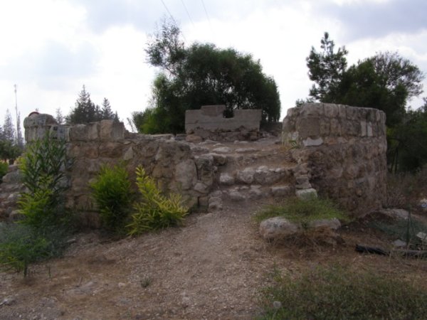
The village site is covered with thorns, cactuses, olive trees, and pine trees, while fragments of stone and concrete from the destroyed buildings remain scattered across the area.
The structure that once protected the village’s central spring and regulated its flow remains standing but has deteriorated and is collapsing in several places. The cemetery also survives, although some grave markers are damaged or falling apart. Agricultural land surrounding the site, particularly in the Acre valley, is cultivated by residents of Yas‘ur.
Sources
- Interactive Encyclopedia of the Palestine Question: al-Damun.
- Interactive Encyclopedia of the Palestine Question: Operation Dekel.
- Walid Khalidi, ed., All That Remains: The Palestinian Villages Occupied and Depopulated by Israel in 1948, Institute for Palestine Studies, 1992.
- Palestine Remembered: al-Damun, Acre Subdistrict.
- Village Statistics of 1945: A Classification of Land and Area Ownership in Palestine.
Photo gallery


Photos from the village's people
Photos sent in by visitors and published after review.
Add a photo of this village
Log in to add photos of this village.
Other villages from Akka (Acre)
 Download Our Palestine App
The whole archive in the palm of your hand: depopulated villages, the Nakba, the massacres and Al-Aqsa — free, with no ads to erase the story.
Download Our Palestine App
The whole archive in the palm of your hand: depopulated villages, the Nakba, the massacres and Al-Aqsa — free, with no ads to erase the story.



Comments
No comments yet — be the first to write one.
Add your comment
Name and email are optional. Comments appear after review.