
The depopulated village of 'Amqa / District of Akka (Acre)
Subdistrict: Acre
Estimated population of 'Amqa in 1948: 1,438
Date of occupation and depopulation: 10–11 July 1948
Military units: The Seventh Brigade and the First Battalion of the Carmeli Brigade
Military operation: Operation Dekel
Israeli settlements established on 'Amqa’s lands before 1948: None
Israeli settlements established directly on the former village site after 1948: None
Israeli settlements established on 'Amqa’s lands after 1948: 'Amqa, established in 1949 immediately north of the village site
'Amqa was a Palestinian village in the Acre Subdistrict. Its inhabitants were displaced in 1948 during Israel’s occupation of Palestine—the Nakba.
On 20 August 1948, the Jewish National Fund submitted a plan proposing 'Amqa and thirty-one other depopulated Palestinian villages as locations for new Israeli settlements. In 1949, an Israeli settlement bearing the name 'Amqa was established on the village’s lands, immediately north of the former built-up site.
Boundaries of 'Amqa
'Amqa was surrounded by the following Palestinian villages and towns:
- North and northwest: al-Ghabisiyya.
- Northeast: Khirbat Jiddin.
- West: Kuwaykat.
- South and east: Abu Sinan.

Geography of 'Amqa
The village stood on a rocky, uneven hill where the slopes of western Lower Galilee met the Acre Plain. It was approximately 11 kilometres from Acre and about 100 metres above sea level. A secondary road connected it to the coastal highway leading to Acre, while other roads and unpaved paths linked it with neighbouring Palestinian villages.
In the late nineteenth century, 'Amqa was described as a stone-built village situated on a slight rise in a valley. Olive and fig trees and cultivable fields surrounded it. Its inhabitants were predominantly Muslims, and the village had a mosque and a school.
Al-Ghabisiyya lay to the north and northwest, Khirbat Jiddin to the northeast, Kuwaykat to the west, and Abu Sinan to the south and east.
Economic Life in 'Amqa
Most inhabitants depended on agriculture and animal husbandry. They cultivated the village lands and produced milk and cheese, which they sold in Acre and neighbouring villages. In 1944/45, 3,348 dunams were devoted to cereal cultivation and 1,648 dunams were irrigated or used for orchards. The Palestinian built-up area covered 36 dunams, while much of the remaining land was used for grazing.
Historical Ottoman records show that the village paid taxes on wheat, barley, olives, cotton, and fruit, as well as on goats and beehives.
Land Ownership in 'Amqa
| Ownership category | Area (dunams)* |
|---|---|
| Palestinian ownership | 6,060 |
| Jewish ownership | 0 |
| Public land | 8 |
| Total | 6,068 |
* One dunam equals approximately 1,000 square metres.
Land Use in 'Amqa in 1944/45
| Land-use category | Palestinian land (dunams)* | Public land (dunams)* | Total (dunams)* |
|---|---|---|---|
| Irrigated land and orchards | 1,648 | 0 | 1,648 |
| Olive groves included within the orchard category | 1,884 | 0 | 1,884 |
| Cereal cultivation | 3,348 | 0 | 3,348 |
| Built-up area | 36 | 0 | 36 |
| Cultivable land | 4,996 | 0 | 4,996 |
| Uncultivated land | 1,028 | 8 | 1,036 |
* One dunam equals approximately 1,000 square metres. The reported olive-grove figure overlaps with the broader agricultural classifications and must not be added separately when calculating the village’s total cultivable area.
Historical Population of 'Amqa
| Year | Population | Type of figure |
|---|---|---|
| 1596 | 215 | Estimate based on Ottoman fiscal records |
| Late nineteenth century | Approximately 300 | Contemporary geographical estimate |
| 1931 | 894 | British Mandate census |
| 1945 | 1,240 | Official population estimate |
| 1948 | 1,438 | Demographic projection |
| Estimated refugee population in 1998 | 8,833 | Later demographic estimate |
The 1948 and 1998 figures are demographic estimates rather than contemporary census counts.
Number of Houses in 'Amqa
| Year | Number of houses |
|---|---|
| 1931 | 212 |
| 1948 | 341 (estimate) |
Landmarks and Archaeological Sites in 'Amqa
The village’s principal landmarks included:
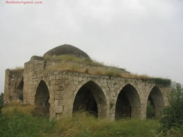
- The mosque: The village mosque was built of local stone and surmounted by a dome. Its northern facade had three large entrances topped by pointed arches. Its precise construction date has not been conclusively established, although local accounts associate it with the Ottoman period. The building remained standing after the village’s destruction, despite cracks and the collapse of parts of its walls.
- Archaeological remains: The village contained an archaeological site with fragments of buildings, water cisterns, and tombs. Several nearby ruins, including Khirbat al-Hanbaliyya, Khirbat al-Muna, and Bir Iklil, contained building foundations, dressed stones, presses, graves, and water installations.
- Wells and water supplies: Local accounts state that 'Amqa had no permanent springs. The inhabitants therefore dug household cisterns and wells to collect water for daily use. During the summer, they also obtained water from springs in neighbouring areas, including al-Kabri and Kuwaykat.
Education in 'Amqa
An elementary school was established in 'Amqa by the Ottoman authorities in 1887. During the British Mandate, its building was enlarged to contain three rooms. Local accounts indicate that teaching was provided through the fourth elementary grade; pupils seeking further education attended school in the neighbouring Palestinian village of Kafr Yasif.
The Mosque of 'Amqa
The mosque was one of the village’s principal architectural landmarks. Constructed from local stone, it was surmounted by a dome, while three large pointed arches defined its northern facade. Although its precise date of construction remains uncertain, it is commonly associated with the Ottoman period. The mosque survived the destruction of the village, but sections of its walls later deteriorated and some stones collapsed.
Occupation and Depopulation of 'Amqa
Although Haganah attacks on Palestinian coastal villages began in December 1947, fighting did not immediately reach 'Amqa. By May 1948, Palestinians displaced from neighbouring villages had begun seeking refuge there.
'Amqa came under attack on 10–11 July 1948 during the first stage of Operation Dekel. Israeli units subjected the village to artillery bombardment as they advanced eastward. The attacking forces were drawn from the Seventh Brigade and the First Battalion of the Carmeli Brigade.
Most of the inhabitants probably left during the artillery bombardment, although evidence indicates that some remained temporarily. Palestinian historian Nafez Nazzal cited eyewitness testimony stating that the bombardment continued into the second truce and that a woman was injured in the village as late as 31 July 1948.
There is therefore a distinction between the initial occupation on 10–11 July and the completion of the village’s depopulation. The evidence indicates that the displacement occurred in stages rather than on a single, precisely documented day.
One account attributed to Benny Morris describes 'Amqa as a Druze village. This conflicts with the demographic and descriptive material reproduced by Walid Khalidi, which identifies the inhabitants as Muslims. In the absence of a verified denominational breakdown supporting the former characterization, it has not been presented here as an established fact.
Israeli Settlements on the Lands of 'Amqa
On 20 August 1948, the Jewish National Fund submitted a settlement plan that included 'Amqa and thirty-one other depopulated Palestinian villages. In 1949, an Israeli settlement also named 'Amqa was established on village land, immediately north of the former village site.
The new settlement was established on the village’s lands rather than directly over its documented built-up centre. The Palestinian school and mosque remained standing at the original site.
'Amqa Today
Wild grasses cover much of the former village site. The mosque and school are the principal surviving buildings. The mosque stands deserted among shrubs, wild vegetation, and the debris of demolished houses.
The school has a gabled roof. New annexes were added to it after 1948, and the complex was subsequently used as a warehouse. The surrounding land has been used for livestock grazing and forage.
Sources
- Interactive Encyclopedia of the Palestine Question: 'Amqa.
- Walid Khalidi, ed., All That Remains: The Palestinian Villages Occupied and Depopulated by Israel in 1948, Institute for Palestine Studies.
- Palestine Remembered: 'Amqa, Acre Subdistrict.
- Nafez Nazzal, The Palestinian Exodus from Galilee, 1948, as cited in Walid Khalidi’s account of 'Amqa.
- Benny Morris, The Birth of the Palestinian Refugee Problem, 1947–1949, as cited by the Interactive Encyclopedia of the Palestine Question.
Photo gallery


Photos from the village's people
Photos sent in by visitors and published after review.
Add a photo of this village
Log in to add photos of this village.
Other villages from Akka (Acre)

 Download Our Palestine App
The whole archive in the palm of your hand: depopulated villages, the Nakba, the massacres and Al-Aqsa — free, with no ads to erase the story.
Download Our Palestine App
The whole archive in the palm of your hand: depopulated villages, the Nakba, the massacres and Al-Aqsa — free, with no ads to erase the story.



Comments
No comments yet — be the first to write one.
Add your comment
Name and email are optional. Comments appear after review.