
The depopulated village of Qumya / District of Baysan
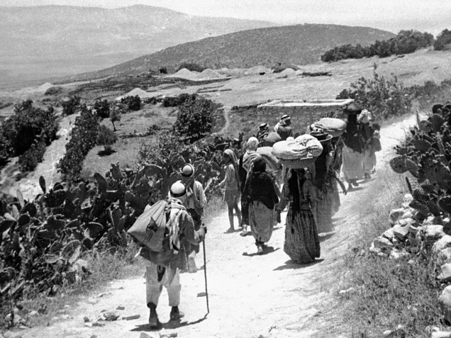
Subdistrict: Baysan
Estimated population of Qumya in 1948: 510
Date of depopulation: 26 March 1948
Cause of depopulation: Fear of attack, insecurity, economic pressure, and possible informal pressure to leave
Military force: No direct military assault or occupying unit has been conclusively documented at the time of the village’s depopulation
Israeli settlements established on land traditionally belonging to Qumya before 1948: En Harod, established in 1921
Israeli settlements established on Qumya’s former built-up area after 1948: None
Qumya was situated approximately 12.5 kilometres northwest of Baysan.
The village stood on a hilltop and, together with the neighbouring village of Shatta, was regarded as a western gateway to the Baysan Plain. The main Baysan–Haifa road passed along the outskirts of the village.
Qumya had an elementary school for boys.
Boundaries of Qumya
Qumya was bordered by the following Palestinian villages and towns:
- North: Na‘ura.
- Northwest: al-Dahi.
- West: Zir‘in.
- Southwest: al-Mazar.
- South: Faqu‘a.
- Southeast: al-Sakhina.
- East: al-Murassas.
- Northeast: al-Tayyiba al-Zu‘biyya, also known as Tayyibat al-Marj.
Archaeological Sites in Qumya
Qumya was known for its archaeological remains. Khirbat Qumya contained the foundations of rectangular buildings, caves, and rock-cut water cisterns. Additional remains found at the village site—including a rectangular structure, architectural fragments, ruins, and dressed or bossed stones—indicate that the location had been inhabited during earlier historical periods.
Ayn Jalud was located approximately 800 metres south of Qumya. It was an archaeological site containing Roman milestones and a large pool cut into the rock.
Architectural Form of Qumya
In the late nineteenth century, Qumya was described as a village built on a knoll in the middle of a valley and surrounded by prickly-pear gardens. Its adobe houses were densely clustered on the hilltop, while vegetable gardens extended across the lower slopes surrounding the hill.
Land Ownership in Qumya, 1944/45
| Ownership category | Area (dunams)* |
|---|---|
| Palestinian ownership | 4,716 |
| Jewish ownership | 81 |
| Public land | 101 |
| Total | 4,898 |
* One dunam equals approximately 1,000 square metres.
Land Use in Qumya, 1944/45
| Land-use category | Palestinian ownership (dunams)* | Jewish ownership (dunams)* | Public land (dunams)* | Total (dunams)* |
|---|---|---|---|---|
| Irrigated land and orchards | 33 | 0 | 0 | 33 |
| Cereal cultivation | 4,205 | 81 | 0 | 4,286 |
| Built-up area | 15 | 0 | 0 | 15 |
| Cultivable land | 4,238 | 81 | 0 | 4,319 |
| Uncultivated land | 463 | 0 | 101 | 564 |
* One dunam equals approximately 1,000 square metres.
Population of Qumya
| Year | Population |
|---|---|
| 1922 | 405 |
| 1931 | 386 |
| 1945 | 440 |
| 1948 | Approximately 510 |
| Estimated refugee population in 1998 | 3,134 |
The 1948 figure is a retrospective demographic projection rather than the number physically residing in Qumya after its depopulation in March 1948. The 1998 refugee figure is also an estimate, not an official census count.
Number of Houses in Qumya
| Year | Number of houses |
|---|---|
| 1931 | 88 |
| 1948 | Approximately 116 |
The 1931 figure is an official census count; the 1948 figure is a later estimate.
Depopulation of Qumya
In the months preceding the outbreak of large-scale fighting, non-military Zionist organisations became involved in efforts to remove Palestinian communities from several villages. The Jewish National Fund, particularly the director of its Lands Department, Yosef Weitz, played an active role in these efforts.
According to Benny Morris, Weitz met other Jewish National Fund officials on 26 March 1948 and called for the removal of the residents of Qumya and nearby al-Tira. He argued that the villagers were not preventing the entry of Palestinian irregular fighters and proposed that they be compelled to leave until the fighting ended.
Most of Qumya’s residents left on the same day, 26 March 1948. Morris attributes their departure to fear of a Jewish attack, a sense of vulnerability, and economic pressure. He states that no formal order was issued to them by neighbouring Jewish settlements but allows that they may have received informal “friendly advice” to leave. The villagers were transported from the area in British Army trucks.
A small group of approximately twelve men remained to guard the village but was subsequently expelled. A few days later, Weitz reported to a superior that Qumya had been depopulated.
The evidence therefore does not support 1 March 1948 as the village’s occupation date. Nor does it identify a conventional military assault or a specific occupying unit on that date. The most thoroughly documented date is 26 March 1948, and the event is more accurately described as depopulation under fear, insecurity, economic pressure, and possible informal coercion, followed by the removal of those who remained.
Four months later, in late July 1948, En Harod applied to the Israeli Agricultural Center for permission to take possession of Qumya’s land. The available account does not establish whether that request received formal approval.
Israeli Settlements on the Lands of Qumya
In 1921, the Zionist settlement of En Harod was established south of the village site on land traditionally belonging to Qumya.
During the early 1950s, En Harod was divided into two independent settlements associated with different branches of the settlement movement: En Harod Ihud and En Harod Meuhad. En Harod Ihud stands on land belonging to Qumya, while En Harod Meuhad stands on land belonging to the neighbouring Palestinian village of Tamra, which remains inhabited.
Geva, also established in 1921, lies approximately 2 kilometres west of Qumya’s former site but was not built on the village’s land.
No separate Israeli settlement was established directly over Qumya’s former built-up area after 1948.
Qumya Today
The entire former village site is fenced. Almond, mulberry, and pomegranate trees, together with prickly-pear cactus, grow around the scattered rubble. Cypress trees stand among the ruins of the village school.
Residents of Tel Yosef, En Harod Ihud, and En Harod Meuhad cultivate land south of the former village, while residents of Geva cultivate land to its west. These present-day agricultural uses do not mean that all the cultivated areas formed part of the formally recorded lands of Qumya.
Sources
- PalQuest, “Qumya”.
- Palestine Remembered, “Qumya — Baysan”.
- Walid Khalidi (ed.), All That Remains: The Palestinian Villages Occupied and Depopulated by Israel in 1948, Institute for Palestine Studies, 1992.
- PalQuest, methodology and sources for depopulated Palestinian villages.
- Government of Palestine, Census of Palestine, 1922.
- Government of Palestine, Census of Palestine, 1931.
- Government of Palestine, Village Statistics, April 1945.
- Benny Morris, The Birth of the Palestinian Refugee Problem Revisited, consulted for the circumstances surrounding Qumya’s depopulation, the role of Yosef Weitz, and the expulsion of the men who remained to guard the village.
Photo gallery


Photos from the village's people
Photos sent in by visitors and published after review.
Add a photo of this village
Log in to add photos of this village.
Other villages from Baysan
 Download Our Palestine App
The whole archive in the palm of your hand: depopulated villages, the Nakba, the massacres and Al-Aqsa — free, with no ads to erase the story.
Download Our Palestine App
The whole archive in the palm of your hand: depopulated villages, the Nakba, the massacres and Al-Aqsa — free, with no ads to erase the story.



Comments
No comments yet — be the first to write one.
Add your comment
Name and email are optional. Comments appear after review.