
The depopulated village of Al-Ja'una / District of Safed

Subdistrict: Safad Subdistrict
Estimated population of al-Ja'una in 1948: Approximately 1,334 Palestinians
Reported date of occupation and depopulation: 9 May 1948. Sources differ over the precise date on which most residents left.
Military operation and units: Operation Yiftach; the Palmach’s First Battalion
Jewish settlement established on land purchased from residents of al-Ja'una before 1948: Rosh Pinna
Israeli-built areas established or expanded over the village site and lands after 1948: Neighbourhoods and extensions of Rosh Pinna
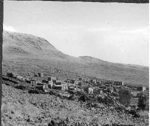
Al-Ja'una was a Palestinian village in the Safad Subdistrict. It was located approximately 5 kilometres east of Safad, on the slopes of Mount Kan'an, at an average elevation of about 500 metres above sea level.
The village overlooked the Ghawr—the low-lying Jordan Valley region—from every direction except the west. It stood near the western side of the road connecting Safad and Tabariyya.
Al-Ja'una’s population was entirely Muslim. Most villagers worked in agriculture or construction. Despite limited water resources, they cultivated cereals, olives, figs, prickly pears and grapes. The village also had an elementary school for boys.
Boundaries and Neighbouring Villages
Al-Ja'una was surrounded by the following Palestinian villages and towns:
- North: Fir'im.
- West: Safad.
- Southwest: Akbara.
- South: Jubb Yusuf.
- East: al-Zanghariyya, also known locally as Zihliq.

Population of al-Ja'una
The British Mandate census of 1922 recorded 626 residents in al-Ja'una. By 1931, the population had risen to 799 Muslims living in 149 houses. The British Mandate’s 1945 Village Statistics recorded 1,150 residents, all of whom were Palestinian Muslims.
The population on the eve of the Nakba has been retrospectively estimated at approximately 1,334, with about 248 houses. These 1948 figures are projections rather than the results of a new official village census. Palestine Remembered estimated the number of refugees from al-Ja'una and their descendants at approximately 8,192 in 1998; this is also a retrospective estimate rather than a census of a single resident population.
Historical Population of al-Ja'una
| Year | Recorded or estimated population | Notes |
|---|---|---|
| 1596 | Approximately 171 | Estimated from Ottoman tax registers. |
| Late nineteenth century | Approximately 140–200 | Contemporary survey estimates vary within this range. |
| 1922 | 626 | Recorded in the British Mandate census. |
| 1931 | 799 | Recorded as an entirely Muslim population living in 149 houses. |
| 1945 | 1,150 | Recorded in the British Mandate’s Village Statistics. |
| 1948 | Approximately 1,334 | Projected estimate rather than a new official census. |
| 1998 | Approximately 8,192 refugees and descendants | A retrospective estimate published by Palestine Remembered. |
Number of Houses in al-Ja'una
| Year | Number of houses | Status of figure |
|---|---|---|
| 1931 | 149 | Recorded in the British Mandate census. |
| 1948 | Approximately 248 | Later estimate; no comparable official 1948 village census has been identified. |
Economic Life in al-Ja'una
Most residents of al-Ja'una worked in agriculture or construction. Although the village had relatively limited water resources, its farmers cultivated cereals, olives, figs, prickly pears and grapes.
In 1944/45, 248 dunams were allocated to cereal cultivation, while 172 dunams of Palestinian-owned land were irrigated or used for orchards. A further 7 dunams of Jewish-owned land were classified as irrigated or orchard land.
Land Ownership in al-Ja'una, 1944/45
| Ownership category | Area (dunams)* |
|---|---|
| Palestinian ownership | 824 |
| Jewish ownership | 7 |
| Public land | 8 |
| Total | 839 |
* One dunam equals approximately 1,000 square metres.
Land Use in al-Ja'una, 1944/45
| Land-use category | Palestinian ownership (dunams)* | Jewish ownership (dunams)* | Public land (dunams)* | Total (dunams)* |
|---|---|---|---|---|
| Irrigated land and orchards | 172 | 7 | — | 179 |
| Olive cultivation, included within the preceding category | 171 | 0 | — | 171 |
| Cereal cultivation | 248 | 0 | — | 248 |
| Built-up area | 43 | 0 | — | 43 |
| Cultivable land | 420 | 7 | — | 427 |
| Uncultivated land | 361 | 0 | 8 | 369 |
* One dunam equals approximately 1,000 square metres.
Education in al-Ja'una
Al-Ja'una had one elementary school for boys. The school had been founded during the Ottoman period and provided instruction through the fourth elementary grade.
Local descriptions indicate that the school stood east of the village. It was built of stone, roofed with tiles and had white-tiled floors.
Occupation and Depopulation of al-Ja'una
The fate of al-Ja'una was closely connected with that of the nearby city of Safad. The village was occupied during Operation Yiftach, a Palmach campaign conducted between mid-April and late May 1948 to seize Safad and establish Zionist control over eastern Galilee. The Palmach’s First Battalion spearheaded the operation.
The precise date on which most residents left al-Ja'una is disputed. Israeli historian Benny Morris states in one account that the evacuation occurred before 2 May 1948 and contributed to panic among the Palestinian residents of Safad. Elsewhere, he dates the village’s depopulation to 9 May, during the final phase of the assault on Safad. The village is therefore commonly assigned an occupation or depopulation date of 9 May 1948, although the available evidence indicates that displacement unfolded in stages.
Some Palestinian residents remained in al-Ja'una after its occupation. On the night of 5 June 1949, Israeli military forces surrounded al-Ja'una and two other villages with trucks and forcibly removed their remaining inhabitants. Contemporary testimony cited by Morris describes physical abuse during the removal. The expelled residents were taken to a barren hillside near Akbara, approximately 5 kilometres southwest of al-Ja'una, where they remained under overcrowded and difficult conditions.
Because a Palestinian population remained until June 1949, the village’s final depopulation cannot be reduced to a single uncontested date. The principal displacement occurred during Operation Yiftach in May 1948, while the documented forced removal of the remaining residents took place on 5 June 1949.
Rosh Pinna and the Lands of al-Ja'una
Rosh Pinna lies southeast of the former village site. Its first settlement was established in 1878 on land purchased from residents of al-Ja'una. After that initial settlement failed, it was re-established in 1882.
Rosh Pinna had fewer than 400 residents at the beginning of 1948. By 1953, its population had increased to approximately 1,480, many of whom were recent immigrants. As the settlement expanded, it extended beyond the land acquired by its original founders and occupied additional land belonging to the depopulated Palestinian village of al-Ja'una.
Al-Ja'una Today
Rosh Pinna now occupies the village site. Many Palestinian houses remain standing. Some have been restored and are used by residents or businesses in Rosh Pinna, while other stone houses are abandoned, damaged or partly destroyed. One of the surviving buildings has an entrance distinguished by a basket-handle arch.
Sources
- Interactive Encyclopedia of the Palestine Question (PalQuest), “al-Ja'una”. The village entry is based substantially on Walid Khalidi’s All That Remains.
- Interactive Encyclopedia of the Palestine Question (PalQuest), “Operation Yiftach”.
- Palestine Remembered, “al-Ja'una—Safad”.
- Walid Khalidi, ed., All That Remains: The Palestinian Villages Occupied and Depopulated by Israel in 1948, Institute for Palestine Studies, 1992.
- Government of Palestine, Census of Palestine, 1922.
- Government of Palestine, Census of Palestine, 1931.
- Government of Palestine, Department of Statistics, Village Statistics, April 1945.
- Benny Morris, The Birth of the Palestinian Refugee Problem, 1947–1949, Cambridge University Press.
Photo gallery


Photos from the village's people
Photos sent in by visitors and published after review.
Add a photo of this village
Log in to add photos of this village.
Other villages from Safed


 Download Our Palestine App
The whole archive in the palm of your hand: depopulated villages, the Nakba, the massacres and Al-Aqsa — free, with no ads to erase the story.
Download Our Palestine App
The whole archive in the palm of your hand: depopulated villages, the Nakba, the massacres and Al-Aqsa — free, with no ads to erase the story.



Comments
No comments yet — be the first to write one.
Add your comment
Name and email are optional. Comments appear after review.