
The depopulated village of Kafr Bir'im / District of Safed
Subdistrict: Safad
Population in 1945: 710, comprising 700 Christians and 10 Muslims
Estimated population in 1948: Estimates vary between approximately 824 and 1,050
Date of occupation: 30–31 October 1948
Date of forced displacement: Early to mid-November 1948
Military operation: Operation Hiram
Military forces: Operation Hiram involved the Seventh, Carmeli, Golani and Oded brigades; the available village-specific sources do not conclusively identify which unit entered Kafr Bir‘im.
Israeli settlements established on the village lands before 1948: None
Israeli settlements established on the village lands after 1948: Bar‘am and Dovev
Israeli settlements established directly on the former built-up site: None
Kafr Bir‘im was a predominantly Palestinian Maronite Christian village in the Safad Subdistrict. It stood on a rocky hill in the Upper Galilee, approximately 11.5 kilometres northwest of the city of Safad and about four kilometres south of the Lebanese border. The village was situated at an average elevation of approximately 750 metres above sea level.
Kafr Bir‘im was surrounded by gardens, olive groves and vineyards, while part of its land was forested. A secondary road connected it with villages to the east and west and led to both the coastal highway and the road to Safad. A customs post operated near the village because of its proximity to the Lebanese border.
The name Kafr Bir‘im may preserve a form of the name of the ancient Canaanite locality Periya‘m, although the etymology is not certain. The village was itself an archaeological site containing remains from several historical periods.
Boundaries of Kafr Bir‘im
Kafr Bir‘im was situated among the following villages and territories:
- North: Lebanon.
- West and southwest: Sa‘sa‘.
- South: al-Jish.
- Southeast: al-Ras al-Ahmar.
- East: Fara.
Population of Kafr Bir‘im
Late nineteenth-century travellers estimated the village population at between 300 and 500. During the British Mandate, Kafr Bir‘im was predominantly Christian. The official 1945 statistics recorded 710 residents: 700 Christians and 10 Muslims.
Published estimates for 1948 vary. Walid Khalidi’s demographic method produces an estimate of approximately 824 inhabitants, while village histories and some studies of the displaced community cite approximately 1,050. Because these figures were calculated retrospectively rather than recorded in a 1948 census, neither should be presented as an uncontested count.
| Year | Population | Source status |
|---|---|---|
| Late nineteenth century | 300–500 | Traveller’s estimate |
| 1922 | 469 | British Mandate census |
| 1931 | 554 | British Mandate census |
| 1945 | 710 | Official village statistics |
| 1948 | 824–1,050 | Retrospective estimates; estimates vary between sources |
| Estimated refugees and descendants in 1998 | 5,058 | Demographic estimate based on the lower 1948 figure |
Number of Houses in Kafr Bir‘im
| Year | Number of houses |
|---|---|
| 1931 | 132 |
| 1948 | 196 (estimate) |
Economy of Kafr Bir‘im
Agriculture
Agriculture was the principal source of livelihood. The abundance of springs supported both rainfed and irrigated cultivation. The inhabitants grew cereals and tobacco as well as fruit trees, particularly olives, figs and grapes. In 1944/45, 3,718 dunams were allocated to cereals and 1,101 dunams were irrigated or used for orchards. Olive trees occupied approximately 143 dunams within the orchard category.
Livestock
The villagers also raised cattle, other livestock and poultry as part of the local agricultural economy.
Local Industries
Local accounts record a grain mill, two olive presses, facilities connected with tobacco processing and small-scale lime production. These activities supplemented agriculture and livestock raising.
Land Ownership in Kafr Bir‘im
| Ownership category | Land area (dunams)* |
|---|---|
| Palestinian ownership | 12,244 |
| Jewish ownership | 0 |
| Public land | 6 |
| Total | 12,250 |
* One dunam equals approximately 1,000 square metres.
Land Use in Kafr Bir‘im in 1945
| Land-use category | Palestinian ownership (dunams)* | Public land (dunams)* | Total (dunams)* |
|---|---|---|---|
| Irrigated land and orchards | 1,101 | 0 | 1,101 |
| Olive cultivation* | 143 | 0 | 143 |
| Cereal cultivation | 3,718 | 0 | 3,718 |
| Built-up area | 96 | 0 | 96 |
| Cultivable land | 4,819 | 0 | 4,819 |
| Uncultivated land | 7,329 | 6 | 7,335 |
* The olive-planted area was included within the irrigated land and orchards category and should not be added separately when calculating the total cultivable area.
* One dunam equals approximately 1,000 square metres.
Archaeological Remains in Kafr Bir‘im
Kafr Bir‘im occupied an important archaeological site. Recorded remains included ancient olive presses, rock-cut tombs, cisterns and the remains of an ancient synagogue. These features indicate that the site was inhabited during several historical periods. The archaeological remains later became part of a designated tourist and archaeological area.
Occupation and Forced Displacement of Kafr Bir‘im
Israeli forces reached and occupied the Kafr Bir‘im area on 30–31 October 1948, during Operation Hiram, the military offensive through which Israel occupied the Upper Galilee during the Nakba. The operation involved forces from the Seventh, Carmeli, Golani and Oded brigades. The available village-specific sources do not conclusively identify which of these units entered Kafr Bir‘im.
The village surrendered without a major battle at the end of October or beginning of November. Its inhabitants were not all immediately expelled at the moment of occupation. Instead, Israeli military authorities subsequently ordered them to leave the village temporarily, ostensibly for security reasons and with assurances that they would be permitted to return.
Accounts differ slightly regarding the precise date of removal, but several studies place the principal expulsion order on or around 13 November 1948. Some inhabitants were forced across the Lebanese border. Others remained nearby or were transferred to al-Jish, where they were placed in houses whose Muslim Palestinian residents had themselves been expelled. Some villagers later returned from Lebanon to the territory controlled by Israel, but they were not permitted to return to Kafr Bir‘im.
The Struggle to Return and the Destruction of the Village
The people of Kafr Bir‘im repeatedly petitioned the Israeli authorities and courts for permission to return. Court proceedings in 1951–1952 found no adequate legal basis for continuing to prevent their return. Sources differ over the dates and precise legal formulation of the rulings, but the decisions were never implemented.
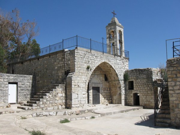
Israeli military authorities kept the village within a closed military zone. In September 1953, the Israeli military destroyed most of its houses, despite the villagers’ continuing legal campaign and the earlier judicial findings concerning their return. The church and its bell tower were spared. The destruction transformed what had been described as a temporary evacuation into lasting displacement.
The displaced villagers and their descendants—many of whom became internally displaced Palestinians—have continued to demand return and restitution. The village church remains a central religious and communal site.
Israeli Settlements on the Lands of Kafr Bir‘im
The Israeli settlement of Bar‘am was established in 1949 northeast of the former village site by former Palmach members. Dovev was established in 1963 northwest of the site. Both settlements occupy land belonging to Kafr Bir‘im, although neither was constructed directly over the village’s original built-up centre.
Kafr Bir‘im Today
The village was largely demolished in 1953. Its church and bell tower remain standing, while collapsed walls, partially ruined houses and extensive stone rubble cover the hillside. Bushes, wild grasses and trees grow among the ruins, and several archaeological remains remain visible.
The village site was closed off, and the surrounding area was designated as an archaeological and tourist site. Despite their prolonged legal and public campaign, the displaced Palestinian inhabitants and their descendants have not been permitted to rebuild and permanently resettle their village.
Sources
- PalQuest, “Kafr Bir‘im”.
- PalQuest, “Operation Hiram”.
- Palestine Remembered, “Kafr Bir‘im—Safad”.
- BADIL, “A Struggle for Restitution: The Case of Kafr Bir‘im”.
- Joseph L. Ryan, “Refugees within Israel: The Case of the Villagers of Kafr Bir‘im and Iqrit,” Journal of Palestine Studies.
- Our Palestine, “Kafr Bir‘im”.
- Walid Khalidi, ed., All That Remains: The Palestinian Villages Occupied and Depopulated by Israel in 1948, Institute for Palestine Studies, 1992.
- Government of Palestine, Census of Palestine, 1922.
- Government of Palestine, Census of Palestine, 1931.
- Government of Palestine, Village Statistics, April 1945.
- Benny Morris, The Birth of the Palestinian Refugee Problem Revisited, Cambridge University Press, 2004.
Photo gallery


Photos from the village's people
Photos sent in by visitors and published after review.
Add a photo of this village
Log in to add photos of this village.
Other villages from Safed

 Download Our Palestine App
The whole archive in the palm of your hand: depopulated villages, the Nakba, the massacres and Al-Aqsa — free, with no ads to erase the story.
Download Our Palestine App
The whole archive in the palm of your hand: depopulated villages, the Nakba, the massacres and Al-Aqsa — free, with no ads to erase the story.



Comments
No comments yet — be the first to write one.
Add your comment
Name and email are optional. Comments appear after review.