
The depopulated village of Al-Ras Al-Ahmar / District of Safed
Subdistrict: Safad
Estimated population of al-Ras al-Ahmar in 1948: Approximately 720
Date of occupation and depopulation: 30 October 1948
Israeli settlements established on the village’s land before 1948: None
Israeli settlements established on the village’s built-up area or lands after 1948: Kerem Ben Zimra
Al-Ras al-Ahmar: Al-Ras al-Ahmar was a depopulated Palestinian village located approximately 8.5 km north of Safad. It was occupied on 30 October 1948 by units of the Israeli Sheva’ (Seventh) Brigade during Operation Hiram.
Al-Ras al-Ahmar Before the Nakba
- The village stood on the flat summit of a high hill known as al-Ras al-Ahmar, meaning “the red peak.” An unpaved road connected it with Safad and passed through the village of Taytaba to the south. Another unpaved road branching from the Safad–Kafr Bir’im road connected the village with Taytaba and al-Rihaniyya.
- The inhabitants were predominantly Muslim. The 1931 British Mandate census recorded 441 Muslims and six Christians, while the 1945 village statistics listed a population of 620, all classified as Muslims. The village had an elementary school for boys established during the British Mandate.
- A spring at the northern edge of the village supplied its inhabitants with water for domestic use. Citrus trees and other fruit trees were cultivated primarily on the lands north of the village.
Boundaries of al-Ras al-Ahmar
Al-Ras al-Ahmar was situated among the following Palestinian villages and localities:
- North: Fara.
- West: Kafr Bir’im.
- South: Taytaba.
- East: al-Rihaniyya.
Economic Life in al-Ras al-Ahmar
A spring at the northern edge of the village supplied the inhabitants with water for domestic use. The villagers cultivated citrus and other fruit trees, particularly on the lands north of the village. During the 1942/43 agricultural season, 350 dunams were planted with olive trees, concentrated to the northwest, southwest, and southeast of the village. In 1944/45, 4,728 dunams were allocated to cereal cultivation, while 1,008 dunams consisted of irrigated land and orchards.
Land Ownership in al-Ras al-Ahmar
| Ownership category | Land area (dunams)* |
|---|---|
| Palestinian ownership | 7,931 |
| Jewish ownership | 0 |
| Public land | 3 |
| Total | 7,934 |
* One dunam equals approximately 1,000 square metres.
Land Use in al-Ras al-Ahmar
| Land-use category | Area (dunams)* |
|---|---|
| Irrigated land and orchards | 1,008 |
| Olive cultivation in the 1942/43 season | 350 |
| Cereal cultivation | 4,728 |
| Built-up area | 61 |
| Total cultivable land | 5,736 |
| Uncultivated land, including public land | 2,137 |
* One dunam equals approximately 1,000 square metres. The olive-growing figure relates to the 1942/43 season and is included within the broader agricultural categories rather than representing an additional area.
Population of al-Ras al-Ahmar
| Year | Population* |
|---|---|
| 1596 | Approximately 418 |
| Late nineteenth century | Estimates ranged from approximately 150 to 350 |
| 1922 | 405 |
| 1931 | 447 |
| 1945 | 620 |
| 1948 | Approximately 719–720 |
| Estimated number of Palestinian refugees descended from the village population in 1998 | 4,417 |
* The 1948 and 1998 figures are demographic estimates rather than contemporaneous census counts. The documented population in the 1945 British Mandate statistics was 620. Estimates vary slightly between sources for 1948.
Number of Houses in al-Ras al-Ahmar
| Year | Number of houses |
|---|---|
| 1931 | 92 |
| 1948 | Approximately 147 |
* The figure for 1931 comes from the British Mandate census. The figure for 1948 is a later estimate rather than a contemporaneous census count.
Education in al-Ras al-Ahmar
The village had one elementary school for boys, established during the British Mandate. Its highest level was the fourth elementary grade.
According to the oral recollections of elderly villagers, an earlier school in al-Ras al-Ahmar was demolished by the British authorities during the Great Palestinian Revolt of 1936–1939. The villagers subsequently built a new school south of the village. Pupils from the neighbouring villages of Dalata and Taytaba also reportedly attended it. This account is preserved as local oral history and could not be independently confirmed in the principal published statistical sources consulted for this article.
Archaeological Remains in al-Ras al-Ahmar
Archaeological remains at al-Ras al-Ahmar included mosaics and wine presses with tessellated floors. These remains indicate that the site was inhabited during the Classical or Byzantine period.
Occupation and Depopulation of al-Ras al-Ahmar
Israeli forces attacked and occupied al-Ras al-Ahmar on 30 October 1948 during Operation Hiram, part of Israel’s occupation of Palestine during the Nakba. The village was captured by units of the Sheva’ (Seventh) Brigade.
According to the historical account reproduced by Walid Khalidi and the Interactive Encyclopedia of the Palestine Question, the villagers appear to have fled after news reached them of the killings at Safsaf and Jish on the previous night. Al-Ras al-Ahmar lay immediately north of those two villages. Israeli reports cited in the historical literature state that the Seventh Brigade found the village largely or completely empty when its units arrived.
Because the available accounts do not establish the precise circumstances in which every resident departed, the relationship between the military advance, news of the killings in neighbouring villages, and the timing of the population’s flight should be stated with appropriate caution. Most of the displaced inhabitants are believed to have sought refuge in Lebanon, as did many Palestinians displaced from northern Galilee during Operation Hiram.
Israeli Settlements Established on the Lands of al-Ras al-Ahmar
In 1949, Israel established the agricultural settlement of Kerem Ben Zimra on the lands of al-Ras al-Ahmar, immediately east of, and possibly partly over, the former village site. Sources therefore support locating the settlement on the village’s lands, although they are less categorical about whether it occupies the entire built-up site.
Al-Ras al-Ahmar Today
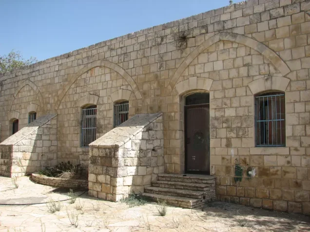
Some of the village’s houses remained standing when the site was documented. One house had a front staircase and a covered garage that appeared to have been added later, while another retained two tall, arched windows. Stone rubble from demolished houses was scattered across the site, where several fig trees and a small number of cactuses also grew. Residents of the neighbouring Israeli settlement cultivated part of the surrounding land and used the remainder for grazing livestock.
Sources
- Interactive Encyclopedia of the Palestine Question: “al-Ras al-Ahmar”, Institute for Palestine Studies.
- Palestine Remembered: “al-Ras al-Ahmar, Safad”.
- Walid Khalidi, ed., All That Remains: The Palestinian Villages Occupied and Depopulated by Israel in 1948, Institute for Palestine Studies, 1992.
- Government of Palestine, Village Statistics, April 1945.
- Our Palestine: “The Depopulated Village of al-Ras al-Ahmar”.
Photo gallery


Photos from the village's people
Photos sent in by visitors and published after review.
Add a photo of this village
Log in to add photos of this village.
Other villages from Safed


 Download Our Palestine App
The whole archive in the palm of your hand: depopulated villages, the Nakba, the massacres and Al-Aqsa — free, with no ads to erase the story.
Download Our Palestine App
The whole archive in the palm of your hand: depopulated villages, the Nakba, the massacres and Al-Aqsa — free, with no ads to erase the story.



Comments
No comments yet — be the first to write one.
Add your comment
Name and email are optional. Comments appear after review.