
The depopulated village of Hunin / District of Safed
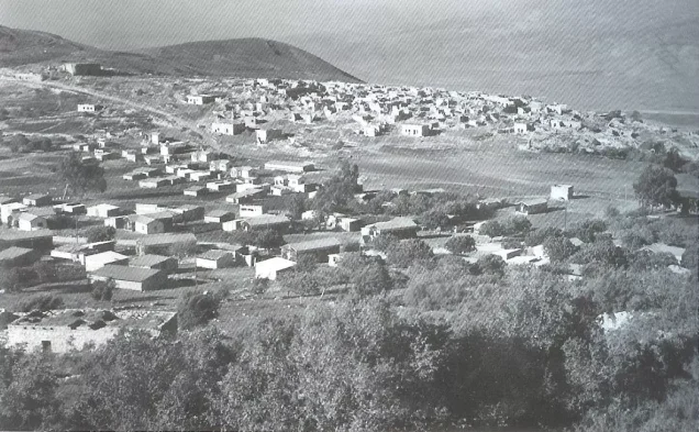
Subdistrict: Safad
Estimated population associated with Hunin in 1948: 1,879
Documented population in 1945: 1,620, including the Lebanese villages of Hula and Udaysa
Occupation and depopulation: The principal displacement occurred in May 1948 during Operation Yiftach; remaining or returning inhabitants were expelled in September, and the village was destroyed by the end of October 1948
Military units: Palmach forces during Operation Yiftach; later Israeli units were involved in the September expulsion and subsequent destruction
Settlement established on village land before 1948: Misgav Am
Settlement established on village land after 1948: Margaliot
- Hunin was a depopulated Palestinian village approximately 28.5 kilometres northeast of Safad.
- The boundary between Palestine and Lebanon passed very close to the village, approximately half a kilometre to its west.
- Although the straight-line distance from Safad was about 28.5 kilometres, the road journey was considerably longer and has been described in local geographical accounts as approximately 42 kilometres.
- Hunin formed part of Lebanon until 1923, when Britain and France delineated the political boundary between Mandate Palestine and Mandate Lebanon and incorporated the village into Palestine.
- Hunin stood on Mount Amil, on a relatively level ridge overlooking the northern part of the al-Hula Plain. Its average elevation was approximately 650 metres above sea level. The higher ground west of the village culminated near the summit of al-Shaykh Abbad, while the eastern slopes descended steeply toward the al-Hula Plain.
- Local geographical accounts identify several water features around the village, including a reservoir on its southwestern edge and the springs of Ayn al-Ajl, Ayn al-Jinjar, and Ayn al-Aqarib. The village also had two principal springs recorded in academic surveys.
Boundaries of Hunin
Hunin was bordered by the following villages and localities:
- North: Lebanon.
- West: Lebanon.
- South: al-Manara.
- East: Al-Khalisa.
- Northeast: Abil al-Qamh.

Population and Public Buildings in Hunin
- In 1931, Hunin had 233 houses. Its built-up area in 1944/45 was 81 dunams, while its total registered land area was 14,224 dunams. Of this land, 486 dunams were under Jewish ownership, equivalent to approximately 3.4 percent of the total.
- The population recorded for Hunin was 1,075 in 1931 and 1,620 in 1945. The 1945 statistical unit included the populations of Hula and Udaysa, two Lebanese villages located respectively west and north of Hunin. The figure therefore should not be interpreted as a count of Hunin’s inhabitants alone.
- Hunin had an elementary school for boys and a mosque. Local accounts assign medieval dates to parts of the mosque and its minaret, but these dates are not consistently confirmed by the principal academic surveys. The surviving historical monument most securely dated by those surveys is the Crusader castle constructed in 1179.
Land Ownership in Hunin
| Ownership category | Land area (dunams)* |
|---|---|
| Palestinian ownership | 13,623 |
| Jewish ownership | 486 |
| Public land | 115 |
| Total | 14,224 |
* One dunam equals approximately 1,000 square metres.
The British Mandate statistical unit for Hunin included Hula and Udaysa in these figures.
Land Use in Hunin, 1944/45
| Land-use category | Palestinian ownership (dunams)* | Jewish ownership (dunams)* | Public land (dunams)* | Total (dunams)* |
|---|---|---|---|---|
| Irrigated land and orchards | 859 | 19 | 0 | 878 |
| Olive groves | 152 | 0 | 0 | 152 |
| Cereal cultivation | 5,987 | 290 | 105 | 6,382 |
| Built-up area | 81 | 0 | 0 | 81 |
| Cultivable land | 6,846 | 309 | 105 | 7,260 |
| Uncultivated land | 6,696 | 177 | 10 | 6,883 |
* One dunam equals approximately 1,000 square metres.
The British Mandate statistical unit for Hunin included Hula and Udaysa. The 152 dunams of olive groves were recorded as a crop-specific figure within the broader cultivated-land categories.
Population of Hunin
| Year | Population |
|---|---|
| 1931 | 1,075 |
| 1945 | 1,620 |
| 1948 | 1,879 (estimated) |
| Estimated number of refugees in 1998 | 11,540 |
The 1931 and 1945 population figures include Hula and Udaysa. The figures for 1948 and 1998 are later demographic estimates rather than contemporary census counts.
Economy of Hunin
Agriculture and animal husbandry formed the basis of Hunin’s economy. In the 1942/43 season, approximately 152 dunams were planted with productive olive trees. Fruit orchards were concentrated northwest, west, southwest, and east of the village.
In 1944/45, 5,987 dunams under Palestinian ownership were allocated to cereal cultivation, while 859 dunams were irrigated or used for orchards. Agricultural land was concentrated principally in the valleys below the surrounding hills.
Historical and Archaeological Importance of Hunin
The Crusaders constructed the fortress known as Chastel Neuf at Hunin in 1179. The Arab traveller Ibn Jubayr, who passed through the region around 1183, described it as a fortress still held by the Franks.
The castle’s defenders surrendered to Salah al-Din al-Ayyubi toward the end of 1187. Crusader forces reoccupied it in 1240, before the Mamluk sultan Baybars expelled them in 1266. The geographer Yaqut al-Hamawi described Hunin as a village in the mountains of Amila overlooking al-Hula, while al-Dimashqi later referred to the castle as an administrative centre governing neighbouring villages.
In the late nineteenth century, travellers described Hunin as a stone-built village adjoining the ruins of the Crusader castle. The village had a mosque and an elementary school for boys.
Occupation and Depopulation of Hunin
The chronology of Hunin’s occupation and depopulation involved several stages and cannot accurately be reduced to 31 October 1948. Like most Palestinian villages in the Galilee Panhandle, Hunin was affected by Operation Yiftach, which Palmach forces conducted in April and May 1948.
A military intelligence report cited by Benny Morris claimed that the inhabitants evacuated the village on 3 May, before Zionist forces had reached it. A separate Palmach report alleged that Arab forces instructed the population to leave by 14 May. These accounts conflict with later eyewitness testimony from residents of neighbouring al-Khalisa. Those witnesses recalled that women and children from al-Khalisa sought refuge in Hunin after the fall of Safad on 11 May, indicating that Hunin was still receiving displaced Palestinians after the alleged evacuation of 3 May.
The inhabitants of Hunin and the Palestinian fighters who had withdrawn there appear to have moved toward Lebanon later in May as Zionist forces advanced through the area. Estimates vary between sources regarding the precise timing and immediate circumstances of this first displacement.
Some inhabitants subsequently remained in or returned to Hunin. In August 1948, village representatives reportedly expressed a willingness to remain peacefully in their homes. Nevertheless, Israeli forces raided the village on 2 September, demolished approximately twenty houses, killed several residents, and expelled those who remained. Benny Morris records twenty Palestinian deaths in this raid, including a son of the village mukhtar, although the exact casualty total is not independently confirmed across all sources.
The village’s final destruction took place by the end of October 1948, during the broader Israeli offensive in the Upper Galilee. Thus, 31 October may refer to the completion of Hunin’s destruction rather than its initial occupation or the beginning of its inhabitants’ displacement. The Carmeli Brigade participated in the wider Upper Galilee operations at that time, but it should not be listed as the sole force responsible for every stage of Hunin’s depopulation.
Israeli Settlements on the Land of Hunin
- Misgav Am was established in 1945 on the northern portion of Hunin’s land.
- Margaliot was established in 1951 on village land immediately south of the former village site. Its first residents included Jewish immigrants from Iraq and Yemen.
Hunin Today
The village cemetery, elementary school, and historic castle remain visible. The castle has been developed as an archaeological attraction, while the school building has been used as an agricultural warehouse. The surrounding lands are cultivated by residents of the Israeli settlements established in the area.
Sources
- PalQuest: Hunin.
- Palestine Remembered: Hunin, Safad.
- Institute for Palestine Studies: Walid Khalidi’s All That Remains.
- Institute for Palestine Studies: Resistance and Survival in Central Galilee, July 1948–July 1951.
- Government of Palestine, Census of Palestine, 1931: Population of Villages, Towns and Administrative Areas.
- Government of Palestine, Department of Statistics, Village Statistics, April 1945.
- Walid Khalidi, ed., All That Remains: The Palestinian Villages Occupied and Depopulated by Israel in 1948, Institute for Palestine Studies, 1992, pp. 455–456.
- Benny Morris, The Birth of the Palestinian Refugee Problem Revisited, Cambridge University Press, 2004, pp. 122–124 and 447–448.
Photo gallery


Photos from the village's people
Photos sent in by visitors and published after review.
Add a photo of this village
Log in to add photos of this village.
Other villages from Safed


 Download Our Palestine App
The whole archive in the palm of your hand: depopulated villages, the Nakba, the massacres and Al-Aqsa — free, with no ads to erase the story.
Download Our Palestine App
The whole archive in the palm of your hand: depopulated villages, the Nakba, the massacres and Al-Aqsa — free, with no ads to erase the story.



Comments
No comments yet — be the first to write one.
Add your comment
Name and email are optional. Comments appear after review.